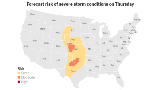
Severe-weather season has begun across the Plains, and forecasters are predicting four days of severe weather that could include tornadoes and large hail.
The area of risk extends from South Dakota to southern Texas beginning on Thursday and shifts east through Sunday. Cities such as Oklahoma City, Kansas City and Dallas could experience severe storms at some point during the period.
Here is what to expect and when.
Hail up to three inches in diameter and tornadoes on Thursday
Parts of northwest Kansas and nearby Nebraska were being pelleted by golf-ball size hail on Thursday evening, and at least three tornadoes had been reported, one near Yoder, Wyo., one near Akron, Colo., and another near Bird City, Kan., Richard Bann, a meteorologist with the National Weather Service, said by phone Thursday.
There were no immediate reports of damage, he said, noting that several other tornado warnings and watches had been issued.
Large hail could also fall across northwest Texas and in central Oklahomalate Thursday and into Friday morning. A few tornadoes are also possible in this region, but the risk is lower.
The threat moves slightly east on Friday
Tornadoes, some possibly becoming strong, could form on Friday across portions of Nebraska, Iowa, Kansas and Missouri, including Kansas City.
The most severe storms are likely to occur in the afternoon and into the evening, with a chance of hail and damaging winds.
A similar pattern on Saturday
On Saturday, the risk becomes more widespread from Texas to Michigan, including Dallas and Milwaukee.
The greatest threat for strong tornadoes returns to the central and southern Plains, again including Oklahoma City and Kansas City. Hail ranging in size from golf balls to baseballs could fall and damaging winds would be possible.
Uncertainty for Sunday
The threat of severe thunderstorms will continue into Sunday, but the precise locations of the areas at greatest risk are unclear, forecasters said Thursday.
Source Agencies


