The National Weather Service in Norman forecasted potential severe weather in the state as Oklahomans prepare for Memorial Day weekend.
The Oklahoma City Office of Emergency Management canceled its weekly noon tornado siren on Saturday in anticipation of severe weather, according to a social media post from the city’s police department.
Here’s what to know about chances of severe weather in Oklahoma during the three-day weekend.
Hail, high wind speeds expected Saturday in Oklahoma
Hail up to softball size and 60-80 mph wind are expected in Oklahoma Saturday, according to NWS Norman.
Updated severe potential for tomorrow (Saturday) and the timing for severe storms. Current cold front will lift tomorrow as a warm front bringing a return of a very moist & unstable environment prior to another cold front pushing through early Sunday. #okwx #texomawx pic.twitter.com/eIxE7A2E2S
— NWS Norman (@NWSNorman) May 24, 2024
The Oklahoma City metro is at a moderate risk of severe thunderstorms along with parts of western Oklahoma and the northern region of the state.
Areas in the far west region of the state are at an enhanced and slight risk for severe thunderstorms, like Altus and Lawton, as well as the south central region, including Ardmore and Durant.
Severe weather is most likely to occur from 5-10 p.m. Saturday in western Oklahoma. In central Oklahoma, severe weather is expected from 7-11 p.m.
Severe thunderstorms, an elevated tornado potential and golf ball to tennis ball size hail are forecasted in the eastern part of Oklahoma on Saturday, according to NWS Tulsa.
Areas near Bartlesville and Tulsa County are at a moderate risk for severe thunderstorms Saturday, areas near Okmulgee, Ada and McAlester are at an enhanced and slight risk and the southeastern part of Oklahoma is at a marginal risk.
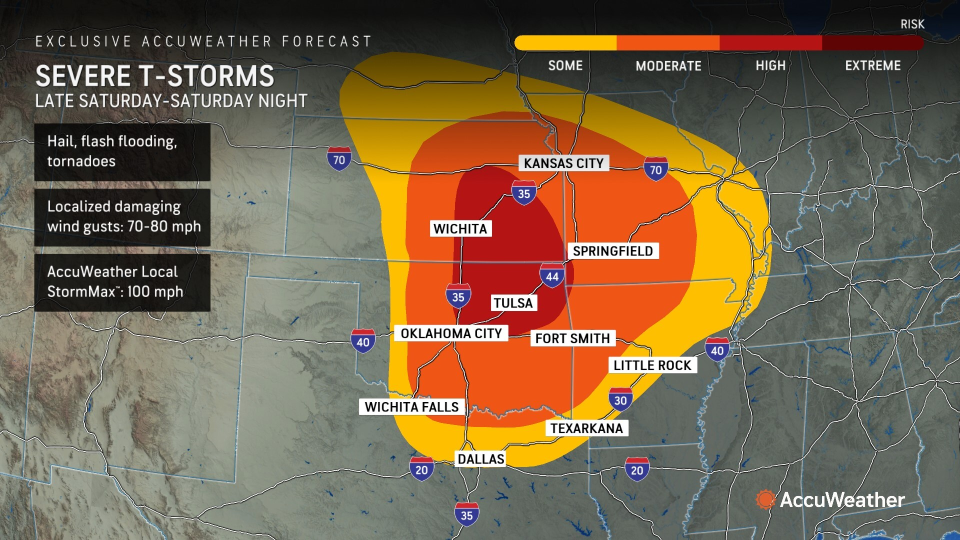
AccuWeather issues ‘high risk’ for severe thunderstorms in central, northeast Oklahoma
In a Friday media advisory, AccuWeather meteorologists issued a “high risk” for severe thunderstorms across central and northeast Oklahoma on Saturday.

Saturday’s storms could produce mind gusts up to 100 mph, which is the same intensity as a Category 2 hurricane, according to AccuWeather.
Will there be tornadoes in Oklahoma during Memorial Day weekend?
NWS Norman expects tornadoes in Oklahoma Saturday afternoon and evening. The weather service advised that strong, long track tornadoes are possible with any storm in any risk area.
As of Friday morning, Oklahoma City county, northern Cleveland County and eastern Canadian County were at a low risk for tornadoes Saturday.
We are still anticipating a potentially significant severe weather event tomorrow afternoon and evening across the entire area. All hazards are expected, especially very large hail and tornadoes. Make sure you check back for updates! #okwx #txwx pic.twitter.com/usqmNlHXQG
— NWS Norman (@NWSNorman) May 24, 2024
Western Canadian County to western Custer County were at a medium risk for tornadoes that day along with areas in the northern part of the state, including parts of Enid.
Areas in the far west region of the state were at a very low risk for tornadoes, like Altus and Lawton, as well as the south central region, including Ardmore and parts of Durant.
Severe thunderstorms forecasted in Oklahoma Sunday
Large hail and damaging winds are forecasted in the southcentral region of the state Sunday afternoon and evening, according to NWS Norman.
Areas east of Stillwater, including Bartlesville and Tulsa county, are at a marginal risk for severe thunderstorms Sunday, according to NWS Tulsa.
Areas east of Tulsa to the Oklahoma-Arkansas border are at a slight risk for severe thunderstorms that day.
Level of categorical severe weather risks explained
The Storm Prediction Center, which is part of the National Weather Service, explained the risk levels associated with severe weather forecasts:
-
Marginal risk (dark green): An area of severe storms of either limited organization and longevity, or very low coverage and marginal intensity.
-
Slight risk (yellow): An area of organized severe storms, which is not widespread in coverage with varying levels of intensity.
-
Enhanced risk (orange): An area of greater (relative to slight risk) severe storm coverage with varying levels of intensity.
-
Moderate risk (red): An area where widespread severe weather with several tornadoes and/or numerous severe thunderstorms is likely, some of which should be intense. This risk is usually reserved for days with several supercells producing intense tornadoes and/or very large hail, or an intense squall line with widespread damaging winds.
-
High risk (magenta): An area where a severe weather outbreak is expected from either numerous intense and long-tracked tornadoes or a long-lived derecho-producing thunderstorm complex that produces hurricane-force wind gusts and widespread damage. This risk is reserved for when high confidence exists in widespread coverage of severe weather with embedded instances of extreme severe (i.e., violent tornadoes or very damaging convective wind events).
This article originally appeared on Oklahoman: Memorial Day weekend weather in Oklahoma may be severe with tornadoes
Source Agencies

