ORLANDO, Fla. – Temperatures on Tuesday will be noticeably less hot than what we saw on Monday (Orlando hit 98°!) due to some early afternoon showers and storms helping to keep clouds in and around the region.
Tuesday’s high temperatures will be a degree or two on either side of 90°.
While a few isolated downpours are possible through the late morning, the majority of the rain won’t arrive until shortly after lunchtime.
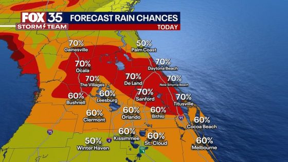
By 1 pm to 2 pm, showers will begin to develop and pop up on the radar. The best chances of storms will take shape from roughly 3pm – 8pm, with the best chances taking place near the I-95 corridor due to the seabreeze.
Our unsettled week continues throughout this week with daily rounds of showers and storms.
A direct moisture-feed from the tropics all week will keep our rain chances elevated with “likely” chances for storms each muggy afternoon.
Any storm will feature frequent and dangerous cloud-to-ground lightning, torrential rain at rates of greater than 5″ per hour, and winds gusting past 40 mph. Temperatures will be gradually getting hotter as well, inching their way into the mid 90s by this weekend.
FOX 35 Storm Tracker Radar
Track live when storms move across your neighborhood with the FOX 35 Storm Tracker Radar below:
More radar maps from FOX 35 Storm Tracker Radar
Stay connected with FOX 35
Source Agencies