In an attempt to understand Austin’s geographic areas, we asked readers how they thought the city of Austin was split up. What does it mean when we say South Austin? Does South Austin include Menchaca or not? How about West Austin? Where does it extend?
With 1,028 responses, the results were a toss-up between the two options that debate the boundaries containing Central Austin — only separated by one percent of total votes. Here’s how readers split the city of Austin:
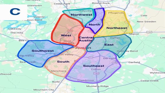
Option 1: Central Austin extends up to Highway 183
With 46.01% of the total votes, Austin readers predominantly chose option “C” of geographic distribution in Austin. As opposed to the second most popular choice, the delineation of Austin’s geographic areas in this option is less “intuitive” and more neighborhood-driven.

-
Central Austin spans from West Cesar Chavez Street in downtown to Highway 183. According to readers’ choice, it encompasses not only Downtown and the University campus but also extends to include areas such as Hyde Park, Allandale, Highland, Crestview, and Wooten. It also covers Old Enfield and Old West Austin.
-
West Austin covers a wide area west of the Mopac freeway, extending up to Highway 183 and beyond the Capital of Texas Highway toward Lake Travis. Neighborhoods within West Austin include Northwest Hills, Tarrytown, Cat Mountain, and it concludes before reaching Steiner Ranch.
-
East Austin stretches from Interstate 35 eastward past Highway 183 to Highway 45, bounded by Highway 290 and Lady Bird Lake. Neighborhoods within this area include Mueller, East Cesar Chavez, Windsor Park, University Hills, Johnson Terrace, and Walter E. Long Lake.
-
North Austin extends beyond Highway 183 up to Interstate 45, nearly reaching Round Rock. It is a narrow but lengthy area encompassing neighborhoods such as Wells Branch, North Burnet, Gracy Woods, and Lamplight Village.
-
Northwest Austin is defined as a narrow area between Interstate Highway 1, Highway 45, and Highway 183. Its largest neighborhood is McNeil.
-
Northeast Austin is located within the 290 Highway north, I-35 and along the 130 Highway. In this delineation option, Pflugerville is included within this area. Dessau is also contained within this.
-
South Austin spans from below Lady Bird Lake southward to West Slaughter Lane, between Interstate 35 and Mopac. Neighborhoods within this area include Congress, Zilker, Bouldin Creek, Barton Hills, Sunset Valley, Manchaca, and Cherry Creek. This delineation aligns with the second most popular option for Austin’s geographic areas.
-
Southwest Austin extends west of the Mopac Freeway and along Lake Austin to Bee Cave and Cedar Valley. This region encompasses neighborhoods such as Rollingwood, West Lake Hills, East Oak Hill, Lost Creek, and Barton Creek.
-
Lastly, Southeast Austin is defined as a large region stretching east of Interstate 35, extending under Lady Bird Lake and spanning over to Interstate 45 and Interstate 130. It includes areas such as Bluff Springs, Pilot Knob, McKinney, and Franklin Park.
Option 2: Central Austin ends just north of the UT campus
Closely following behind, with 45.14% of the total votes, the second most popular option “A” presented an intuitive distribution of the areas of Austin.

-
Central Austin Spans from Downtown Austin northward to West Koenig Lane, between Interstate 35 and Mopac freeway. It is a more compact delineation compared to the first, most popular option. Includes Downtown, the University Campus area, Old Enfield, Rosedale, The Triangle, Old West Austin, and Hyde Park. There is no distinction between Downtown Austin and Central Austin.
-
South Austin Ranges from below Lady Bird Lake southward to West Slaughter Lane, between Interstate 35 and Mopac. Neighborhoods within this area include Congress, Zilker, Bouldin Creek, Barton Hills, Sunset Valley, and Cherry Creek.
-
West Lake Hills, Lost Creek, East Oak Hill, Rollingwood and Barton Creek neighborhoods are all part of Southwest Austin. The delineation extends near Lakeway and Bee Cave.
-
As for Southeast Austin, it spans from I-35 highway until I-30, near the Austin-Bergstrom Airport. This area contains Riverside, Parker Lane, Montopolis and Bluff Springs.
-
West Austin includes Tarrytown, extends past the Capital of Texas Highway and ends shortly before Steiner Ranch.
-
East Austin falls between I-35, 183 Highway and Highway 290. It includes Muller, Windsor Park, University Hills, Pecan Springs-Springdale and Johnson Terrace area.
-
North Austin spans past W Koenig ln until W Parmer ln. It is contained within I-35 highway and Mopac and includes North Burnet, Allandale, Gracy Woods.
-
Northwest Austin extends left of Mopac freeway and includes the surrounding areas of the Capital of Texas highway. Northwest Hills and Cat Mountain are included in the area.
-
Lastly, Northeast Austin is within E Parmer Ln, or 734 highway, 290 and I-35. It contains the neighborhoods of Windsor Hills, Heritage Hills, St. Johns, Copperfield and Bellingham Meadows.
See another option readers shared on how to split Austin’s geography

The proposed distribution simplifies Austin’s areas into only North, South, East, and West.
-
According to this plan, North Austin spans north of the river, encompassing East Austin (the neighborhood,) Downtown, the University campus, North Lamar, Hyde Park, and extending to Gracy Woods. It also includes East Cesar Chavez, Mueller, and Windsor Park. This version of North Austin covers a larger area compared to previous options.
-
East Austin comprises areas east of Highway 183 and beyond Highway 71, including Daffan, Manor, and Hornsby Bend. In this distribution, the area does not include the East Austin neighborhood and instead starts eastward of it.
-
South Austin includes all areas south of the river, such as Sunset Valley, South Congress, Zilker, and extending south to Manchaca.
-
West Austin covers the regions west of the Mopac freeway, including West Lake Hills, Tarrytown and extending to Bee Cave and reaching Lake Travis.
This article originally appeared on Austin American-Statesman: North, south, east and west: How readers split up Austin’s geography
Source Agencies