Saharan dust approaching from the east is expected to arrive in South Florida today, bringing drier air, according to the National Weather Service Miami.
Don’t expect the dust to reach the west coast before showers and storms arrive.
That dust is helping keep the tropics quiet. The dust, along with wind shear, helps prevent storms from developing and strengthening.
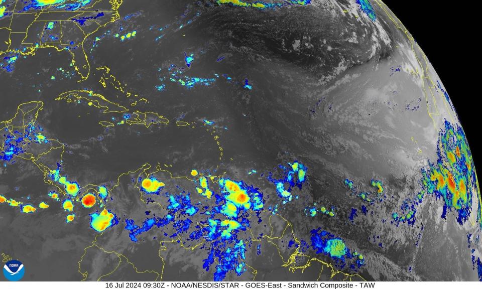
No disturbances were highlighted on the tropical outlook map this morning, according to the latest advisory from the National Hurricane Center.
Forecasters are monitoring three tropical waves, including one in the Caribbean.
Historically, the peak of hurricane season runs from mid-August through mid-October. If your hurricane supplies are running low, or you haven’t started an emergency kit, Florida’s next sales tax holiday the end of August can help you save money.
Heat advisories issued for some Florida counties. Heat index could hit 112
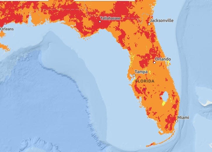
Meanwhile, heat advisories continue to be issued across portions of Florida. Here’s the heat index expected today:
What else is in Florida’s forecast today?
-
Pensacola: 30% chance for showers. High of 90.
-
Tallahassee: 70% chance for thunderstorms. High near 94.
-
Jacksonville: 70% chance for thunderstorms. High 95.
-
Daytona Beach: 50% chance for showers. High 91.
-
Melbourne: 40% chance for showers and thunderstorms. High near 90.
-
Port St. Lucie: 20% chance for showers. High 92.
-
West Palm Beach: 20% chance for showers. High 86.
-
Naples: 30% chance for thunderstorms. High 91.
-
Fort Myers: 40% chance for scattered thunderstorms. High 93.
-
Sarasota: 40% chance for scattered thunderstorms. High 90.
How long will tropics remain quiet?
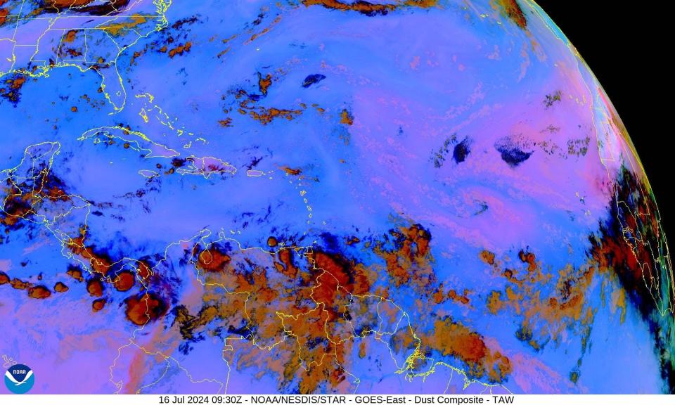

“There is a lot of dry air and dust moving off of Africa and spreading across the Atlantic” said Alex DaSilva, AccuWeather lead hurricane expert.
“With all the dust and dry air around, it will make it very difficult for anything to develop over the next 7-10 days. There are signs that at the very end of the month and into the start of August, the dry air may begin to back off and atmospheric conditions are looking a little more favorable for tropical development.”
Where do July storms usually develop?
“This could also be the time of year when development can start to occur all across the entire basin,” DaSilva said.
“Usually — Beryl was a huge exception — early in the season there is almost no development east of the Lesser Antilles. As we move into August, we need to start watching the tropical waves moving off of Africa as they can develop more quickly as we get later into hurricane season.”
Rapid intensification of hurricanes concerning
Rapid intensification is an increase in wind speeds of about 35 mph over 24 hours.
“I am still very concerned about rapid intensification as we move later into the summer. One of the main reasons Beryl was able to become a Cat 5 was because of the record-breaking warm waters for this time of year across the Main Development Region,” DaSilva said.
“These water temperatures are only going to increase from here, making the basin prime for rapid intensification. I think that as long as we continue to see sea-surface temperatures increasing across the Atlantic, rapidly intensifying storms are something we are going to deal with as we move into the future,” DaSilva said.
What are chances of hurricane impacting Florida?

“Since our forecast was released in March, we have been concerned about the Texas coast, Panhandle of Florida, South Florida and the Carolinas as having an increased chance of tropical impacts,” DaSilva said.
➤ Will hurricane hit Florida during 2024 season?
“We continue to be concerned about those areas. Everyone living in hurricane areas should always have their hurricane plans ready to go.
“We’re still expecting a very, very busy season,” DaSilva said. “Don’t let your guard down. Don’t be fooled by the quiet period. We’re at the very beginning of hurricane season. It will ramp up and it could ramp up very quickly.”
The next storm of the season will be Debby.
Here’s the latest update from the NHC as of 2 a.m. July 16:
What is NOAA tracking in Atlantic basin?


The National Hurricane Center said no tropical cyclone activity is expected over the next several days.
Elsewhere in the tropics, the National Hurricane Center is monitoring three tropical waves:
-
Tropical wave 1: A tropical wave in the central Atlantic is moving west at 6 to 11 mph.
-
Tropical wave 2: A tropical wave in the western Atlantic extends from Barbados to northern Suriname. It’s moving west at 17 to 23 mph.
-
Tropical wave 3: A tropical wave in the western Caribbean extends from the Gulf of Mexico across Honduras and Nicaragua into the eastern Pacific. It’s moving west at 23 mph.
Who is likely to be impacted?
Forecasters urge all residents to continue monitoring the tropics and to always be prepared. That advice is particularly important for what is expected to be a very active hurricane season.
When is next Florida hurricane tax-free supplies holiday?


Save on hurricane supplies between Aug. 24 and Sept. 6. This will be the final tax-free holiday for 2024 when it comes to emergency supplies and it comes during the busiest period of the hurricane season.
Can’t afford a generator or weeks of food? Here are the basics you should have on hand.
Eligible items included in the tax-free holiday include:
-
A portable generator used to provide light or communications or preserve food in the event of a power outage with a sales price of $3,000 or less.
-
A tarp or other flexible waterproof sheeting with a sales price of $100 or less.
-
An item normally sold as, or generally advertised as, a ground anchor system or tie-down kit with a sales price of $100 or less.
-
A smoke detector or smoke alarm with a sales price of $70 or less.
-
A fire extinguisher with a sales price of $70 or less.
-
A carbon monoxide detector with a sales price of $70 or less.
-
A nonelectric food storage cooler with a sales price of $60 or less.
-
A portable power bank with a sales price of $60 or less.
-
A gas or diesel fuel tank with a sales price of $50 or less.
-
A portable self-powered radio, two-way radio, or weather-band radio with a sales price of $50 or less.
-
A package of AA-cell, AAA-cell, C-cell, D-cell, 6-volt, or 9-volt batteries, excluding automobile and boat batteries, with a sales price of $50 or less.
-
A portable self-powered light source (powered by battery, solar, hand-crank, or gas) with a sales price of $40 or less, including: flashlights, lanterns and candles.
-
Eligible light sources and radios qualify for the exemption, even if electrical cords are included in the purchase.
-
Reusable ice (ice packs) with a sales price of $20 or less.
➤ See full list of items, including pet and cleaning supplies, exempt from sales tax
Weather watches and warnings issued in Florida
When is the Atlantic hurricane season?
The Atlantic hurricane season runs from June 1 through Nov. 30.
When is the peak of hurricane season?
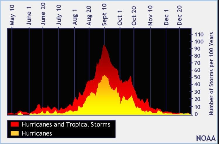

The peak of the season is Sept. 10, with the most activity happening between mid-August and mid-October, according to the Hurricane Center.
National Hurricane Center map: What are forecasters watching now?
Systems currently being monitored by the National Hurricane Center include:


Interactive map: Hurricanes, tropical storms that have passed near your city
Excessive rainfall forecast
What’s next?
We will continue to update our tropical weather coverage daily. Download your local site’s app to ensure you’re always connected to the news. And look for our special subscription offers here.
This article originally appeared on Treasure Coast Newspapers: NHC tracking tropical waves as Saharan dust expected in Florida
Source Agencies


