The National Hurricane Center‘s new experimental tropical cyclone forecast cone graphic will be coming out in mid-August, just in time for the peak period of hurricane season.
The new cone will add tropical storm and hurricane watches and warnings for interior counties in the path of the storm. The current cone displays watches and warnings only for coastal counties.
Watches and warnings for interior counties have been provided by local National Weather Service offices. The new graphic will combine tropical storm and hurricane watches and warnings into a single graphic.
The Atlantic hurricane season runs from June 1 through Nov. 30., and the most active period runs from mid-August through mid-October. The peak of the season is Sept. 10.
What’s different with the National Hurricane Center’s ‘cone of uncertainty’?

The new experimental cone will reflect watches and warnings issued for interior counties, not just those along the coast.
Previous NHC cones showed the projected path of a tropical storm or hurricane, as well as the timing of the storm and any watches and warnings for coastal areas.
The new graphic will continue to have the same information but also illustrate potential impacts for areas away from the coast.
The watches and warnings will take precedence over the cone, the National Hurricane Center said.
Differences you’ll see:
-
Watches and warnings for inland counties, not just coastal areas.
-
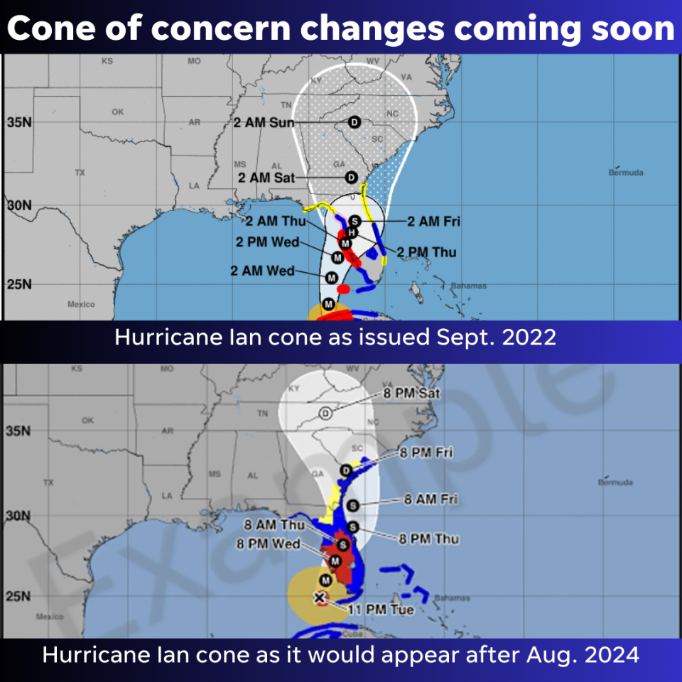
White transparent shading for the entire five-day forecast, instead of white stippling (dots) for the four- and five-day forecast.
Why is changing the NHC cone important?
With the previous emphasis on watches and warnings issued along Florida’s coasts, many inland residents and visitors were unaware of the wind dangers an approaching storm could have well away from the coast. The new cone emphasizes inland watches and warnings.
“This change will give us a more complete depiction of the wind risk,” NHC Deputy Director Jamie Rhome said.
The NHC said research has suggested the addition of inland watches and warnings to the cone graphic “will help communicate inland wind risk during tropical cyclone events while not overcomplicating the current version of the graphic with too many data layers.
“The impetus was to better depict the full scope of the wind hazard over inland areas. This is most critical for strong hurricanes that can carry tropical storm and hurricane force winds well inland, but it will improve the risk communication for wind hazards for all tropical cyclones,” the Hurricane Center said.
De-emphasizing National Hurricane Center’s cone of uncertainty
The National Hurricane Center is also hoping placing the emphasis on warnings and watches will de-emphasize the cone most people tend to focus on.
“As you look at the graphic, your eyes naturally gravitate to what is ultimately more important, which is the risk that comes with the storm,” Rhome said.
The cone only indicates where the center of the storm is most likely to be. Then a series of circles is drawn for every 12 to 24 hours over the forecast period. The cone encompasses those circles.
An important point to remember: The five-day track stays within the cone about two-thirds of the time, but the center of the storm moves out of the cone about a third of the time, said Jamie Rhome, National Hurricane Center deputy director.
For the 2024 Atlantic hurricane season, the margin of error ranges from 41 nautical miles in any direction at 24 hours to 102 nautical miles at 72 hours. That’s about the distance from Miami to Stuart or from Jacksonville to New Smyrna Beach.
The cone does not indicate the size of the storm and it doesn’t indicate all of the areas that could be affected by wind, rain, storm surge, or tornadoes.
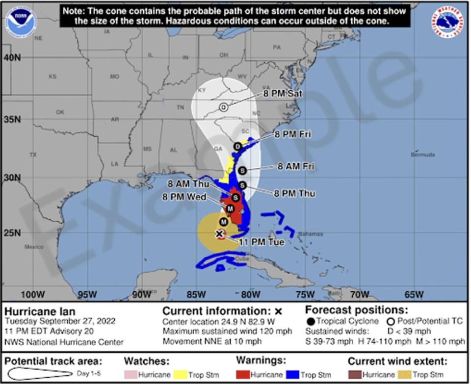
Compare Hurricane Ian’s 2022 cone with the experimental cone coming August 2024
Use the slider on the right to compare the prior cone to what it will look like beginning August 2024.
Hurricane Ian posed dangers across almost the entire state, not just Southwest Florida’s coastal counties, but the original cone released as Hurricane Ian approached Florida only showed watches and warnings along the coast.
The experimental cone shows hurricane warnings for Ian well into Central Florida and tropical storm warnings along the entire East Coast and North Florida as the storm moved across the state.
Hurricane Ian: Were forecasts for Hurricane Ian wrong? What experts say about the ‘cone of uncertainty.’
Hurricane, tropical storm watches and warnings to stay same colors
Watches will continue to be displayed in pink for hurricanes and yellow for tropical storms.
Warnings will continue to be displayed in red for hurricanes and blue for tropical storms.
The experimental version of the cone will use white transparent shading for the entire five-day forecast, instead of using white stippling for the four-to-five-day portion of the forecast as it is in the current version. The entire outline of the cone will be in white.
When will the National Hurricane Center start using the new cone?
2/1 at 9am: The National Hurricane Center (@NHC_Atlantic) will be implementing a new experimental cone graphic beginning on or around August 15th 2024.
This experimental graphic will help better convey wind hazard risk inland in addition to coastal wind hazards. pic.twitter.com/pDkNiRoupx
— NWS Miami (@NWSMiami) February 1, 2024
The change will be put into practice on or around Aug. 15.


The new cone may not be posted online as quickly as the existing graphic since it takes time to compile inland watches and warnings, the NHC said. It should generally be available within 30 minutes of each advisory release.
The Hurricane Center issues advisories on storms every 3 hours, starting at 2 a.m. Additional updates are issued as warranted, including at landfall and as a storm strengthens.
An automated system that’s been in use for decades for a variety of services will now pull watches and warnings issued by local National Weather Service offices and place them on top of the National Hurricane Center cone, said Robert Garcia, senior meteorologist with the National Weather Service Miami.
Public comments to be gathered on experimental hurricane cone
“We bring new features or new additions and open these new features up for people to provide comments to us,” Rhome said.
“At the conclusion of the experiment, we use those comments to determine whether to make the change permanent, to discontinue the change or to evolve the change but in a different iteration.”
A link to provide feedback will be provided by the National Hurricane Center when the new cone is implemented.
Cone of uncertainty has been confusing to many
Ever since the National Hurricane Center started issuing the cone graphic in 2002, forecasters have found it often has been misunderstood and used in ways it wasn’t meant to.
The cone is intended to depict where the center of the storm could go. So a cone that stretches from Sarasota to Naples means the center of a hurricane could come ashore in Sarasota, or the eye of the hurricane could make landfall in Naples. And for one-third of the time, the center could be north or south of those areas.
And to emphasize: that’s the center of the storm where the strongest winds occur. Hurricanes can be hundreds of miles wide, so tropical-storm-force winds could be felt far from the center.
The cone is created by enclosing the area swept out by a set of circles — which aren’t shown — along the forecast track every 12 hours for the first three days and then at 24 hours for days four and five. The size of each circle is set so that two-thirds of historical official forecast errors over a five-year sample fall within the circle.
In other words, the center of the storm stays within the cone for roughly two out of every three forecasts, the National Hurricane Center said.
The cone does not depict the size of the storm or the areas that could experience high winds, intense rainfall, or storm surge.
NHC cone also known as ‘cone of death’
The National Hurricane Center’s cone is known by several names, including the “cone of concern,” the “cone of death” and the “cone of uncertainty.”
Names for 2024 Atlantic hurricane season
Names for the 2024 Atlantic hurricane season are:
-
Alberto: Tropical Storm Alberto formed June 19 in western Gulf of Mexico.
-
Beryl: Tropical Storm Beryl formed June 28 east of Windward Islands. It became a major hurricane before making the first of three landfalls in Carriacou Island, Grenada, with 150-mph winds.
-
Chris: Tropical Storm Chris formed in the Gulf of Mexico June 30.
-
Debby
-
Ernesto
-
Francine
-
Gordon
-
Helene
-
Isaac
-
Joyce
-
Kirk
-
Leslie
-
Milton
-
Nadine
-
Oscar
-
Patty
-
Rafael
-
Sara
-
Tony
-
Valerie
-
William
This article originally appeared on Treasure Coast Newspapers: NHC cone of uncertainty changes coming around August 15
Source Agencies


