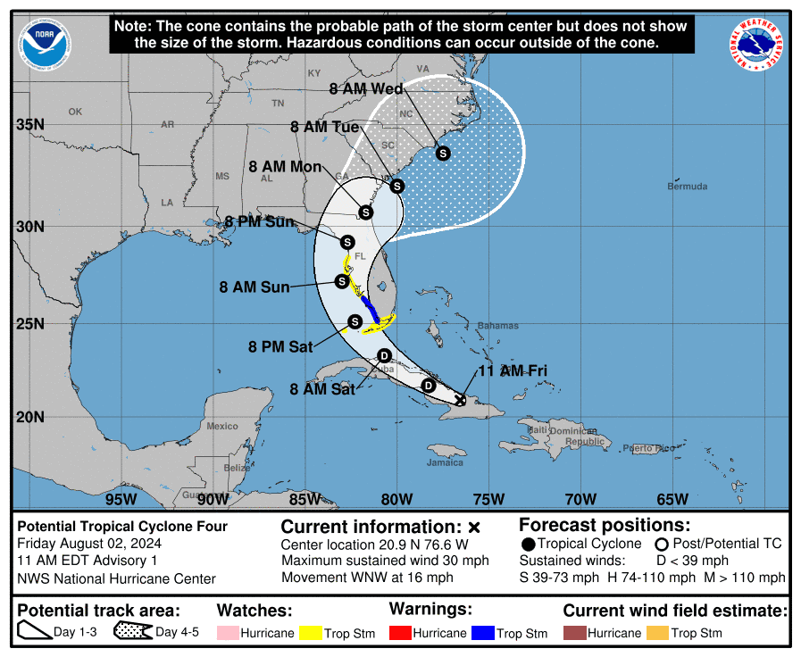
Sarasota and Manatee counties are currently in the projected path of tropical wave Invest90L, which the National Hurricane Center expects to develop further. If sustained winds top 39 mph, it would become Tropical Storm Debby, the fourth named storm of the Atlantic hurricane season.
In 2012, Sarasota was hit by another Tropical Storm Debby that flooded streets, damaged roofs and sank boats.
Come here for the latest updates on the forecast for the Sarasota area, cancellations and closures, and what you may need to do to prepare as we update this blog with the latest information.
➤ Spaghetti models for Invest 97L
What conditions could Sarasota and Manatee counties see?
According to the latest rainfall distribution map from the National Hurricane Center’s 11 a.m. advisory, coastal Sarasota and Manatee counties could see 6 to 8 inches of rain over the next five days and inland areas 4 to 6 inches.
Flash flooding is currently a slight risk for the area.
There is a 20% to 30% probability of tropical storm force winds for the area, though the estimate could change as the system gets closer. The most likely arrival time for tropical storm force winds was shown on a map to be between 8 p.m. Saturday and 8 a.m. Sunday.
Manatee County opens sandbag locations ahead of potential tropical storm
Manatee County Public Works crews are setting up self-serve sandbag locations for residents who may want to secure their property in advance of the tropical system forecast to impact Sarasota and Manatee counties.Sand and bags will be available beginning at noon today at:
-
Coquina Beach (near the Bus Loop) at 1507 S. Gulf Dr. in Bradenton Beach
-
Lincoln Park at 501 17th Street East in Palmetto
-
Manatee County Utilities Headquarters at 4410 66th Street W. in Bradenton
Follow official storm information from Manatee County at mymanatee.org/storm or by registering for Alert Manatee.
11 a.m. National Hurricane Center update: Tropical Storm Warnings and Watches hit Florida, Sarasota directly in storm’s path
At 11 a.m., the disturbance was centered near latitude 20.9 North, longitude 76.6 West.
The system is moving toward the west-northwest near 16 mph. A turn toward the northwest at a slower forward speed is expected tonight or Saturday, followed by a turn toward the north on Sunday.
On the forecast track, the disturbance is expected to move over Cuba today, cross the Straits of Florida on Saturday, and then move near or over the west coast of Florida, with Sarasota and Manatee counties in the center part of the path.
Maximum sustained winds are near 30 mph, with higher gusts.

The disturbance is expected to develop into a tropical depression on Saturday as it moves across the Straits of Florida, followed by intensification into a tropical storm by Saturday night.
A Tropical Storm Warning has been issued for southwest Florida from East Cape Sable to Bonita Beach.
The estimated minimum central pressure is 1012 mb.
-
Formation chance through 48 hours: high, 70 percent.
-
Formation chance through 7 days: high, 90 percent.
Manatee County declares State of Emergency ahead of potential Tropical Storm Debby
Manatee County declared a local State of Emergency during a special meeting of county commissioners Friday morning, in advance of anticipated severe weather over the next several days due to the approaching tropical wave currently known as Invest97L.
“It’s important for the public to monitor the storm and prepare for the possible flooding effects,” said Manatee Board of County Commissioners (BOCC) Chair Mike Rahn, in a release.
The declaration of a local State of Emergency allows county staff to perform any emergency actions needed during the storm as well as “the ability to get resources from the state when needed,” said Public Safety Director Jodie Fiske.
Manatee County has declared a Local State of Emergency in advance of anticipated severe weather over the next several days as current forecast(s) for Invest 97L predict significant rainfall across FL, including Manatee. Follow official storm info at https://t.co/fBnwYQqygm. pic.twitter.com/SrexJNAuW5
— Manatee County Government (@ManateeGov) August 2, 2024
Remember when Tropical Storm Debby hit Sarasota, Bradenton in 2012?
In 2012, Tropical Storm Debby — a relatively weak player on the spectrum of storms — wreaked havoc in Sarasota and Manatee counties.
According to Herald-Tribune reporting, the storm’s “incessant rains and gusting winds overloaded waste-water plants and left more than 10,000 without power” in the area.
Take a look:
What is the latest forecast for the tropical wave impacting Sarasota, Bradenton?
As the tropical system dubbed Invest97L continues its path towards Sarasota and Manatee counties, the National Hurricane Center now expects that “tropical storm watches or warnings could be required for portions of Florida later today.”
According to the latest NHC forecast, environmental conditions are expected to be conducive for additional development after it passes over or near Cuba, “and a tropical depression is likely to form this weekend over the Straits of Florida or eastern Gulf of Mexico near the Florida Peninsula.”
“Regardless of development, heavy rains could cause areas of flash flooding across Florida, Cuba, and the Bahamas through the weekend,” says the NHC.
The storm now has a 60% for formation in the next 48 hours and a 90% chance of formation through the next seven days.
“Landfall could occur sometime between late Sunday and early Monday just about anywhere from Apalachicola to the Tampa Bay area,” said National Weather Service forecasters.
This article originally appeared on Sarasota Herald-Tribune: Live storm updates: Sarasota, Bradenton in likely path of developing
Source Agencies

