The Naples area could be in for heavy rainfall this weekend as a tropical wave continues to churn in the Caribbean.
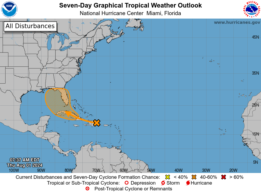
Hurricane experts are tracking the wave, called Invest 97L as of Thursday morning and expect it to impact the Naples area soon. Gov. Ron DeSantis declared a state of emergency for most of Florida on Thursday evening.
“There’s some drier air that will also be in place Friday, but as the tropical wave moves northwest it’s going to bring moisture and it looks like it’s going to stay to the east,” said Will Redman, a meteorologist with the National Weather Service in Miami, which covers the Naples-Collier County area. “It might shift more Saturday night and Sunday.”
The wave is expected to move into the Gulf of Mexico over the weekend. Beyond that, models show various scenarios.
One possibility is that the wave will get stuck in the southeastern Gulf of Mexico for several days, which would bring heavy rains daily to this region. Another possibility is that the front stays 70 or 80 miles offshore, meteorologists say.
Region already above-average for rainfall this summer
Southwest Florida really doesn’t need the rain as the Lee-Collier area is, on average, about 8 inches above average for rainfall for this summer, according to South Florida Water Management District records.

“I would say the rain will start on Saturday,” Redman said. “The ensembles don’t have a consensus on this thing at this point.”
Hurricane experts are giving the wave a 20% chance of forming into a named storm over the next 48 hours.
More: Wilderness designation planned for the Big Cypress fails. Why some groups are happy
“A well-defined tropical wave is producing a large area of disorganized showers and thunderstorms over Hispaniola, Puerto Rico, the Virgin Islands, and the adjacent waters of the southwestern Atlantic and northeastern Caribbean Sea,” a Thursday morning National Hurricane Center report reads.
Conditions more conducive to tropical storm formation are expected next week.


“Environmental conditions are forecast to be more conducive for development after the wave passes the Greater Antilles, and a tropical depression could form this weekend or early next week over the eastern Gulf of Mexico or near the Florida Peninsula,” an NHC forecast reads.
This article originally appeared on Fort Myers News-Press: What is Invest 97L and how will it impact Naples area
Source Agencies


