City of Savannah officials said Friday they are bracing for another potential round of flood-producing rainfall beginning Sunday – and they urged residents to do the same.
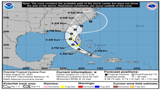
A weather system moving through the Atlantic is expected to strengthen into a tropical storm before moving over Florida late Saturday and likely taking a right turn and moving over the Georgia coast by Monday, the National Hurricane Center cautioned Friday.
The system, which would be named Debby if it reaches tropical storm strength, will likely weaken considerably by the time it reaches Georgia but still could dump several inches of rain in the Savannah area, forecasters say.
That could set the area up for a potential fourth round of street flooding over a two-week period, Savannah officials warned.
Areas of the city experienced as much as 3 inches of rain per hour from the most-recent storms.
Emergency officials responded to 40 to 50 calls from motorists stranded in floodwaters across the three rain events and removed 13 people from swamped vehicles, Assistant Savannah Fire Chief William Handy said Friday.
As the rain fell and water collected on roads, representatives from the fire, police, and water and sewer departments erected warning signs for drivers.
“I can’t stress enough how people – I guess in a certain way of traveling home – were still continuing to go through those flooded areas even as the signs were being deployed,” Handy said. “So just be cautious and concerned and if you start experiencing that, back out and turn around.”
Cause and effect: Savannah’s more-frequent flooding fueled by climate-induced extreme rain

What’s ahead
Here’s a look at the weekend weather forecast, according to the National Weather Service:
Saturday: Mostly sunny with 50 percent chance of showers and thunderstorms, mainly after 11a.m. High temperatures near 93 degrees and heat index values as high as 106. Wind gusts as high as 20 mph are possible.
Sunday: Showers and thunderstorms with highs near 88. Up to 1 inch of rain is possible.
Sunday night: Showers and thunderstorms, mainly before 8 p.m. Low around 76. Between 1 and 2 inches of rain are possible.
Monday: Showers and thunderstorms likely with a high near 86. Chance of precipitation is 70%.
Problem flooding areas
Here are flood-prone areas that motorists should avoid during extreme rain, according to the City of Savannah:
Alternate routes in heavy rain
-
From Downtown to Midtown: MLK Jr. Boulevard, 37th Street., Bull Street and White Bluff Road, DeRenne Avenue, Abercorn Extension
-
From Downtown to Southside: MLK Jr. Boulevard, I-16, I-516/Lynes Parkway, Southwest Bypass/Veterans Parkway, GA 204/Abercorn Extension.
-
From Downtown to Islands: Bay Street, East Broad Street, Wheaton Street, Ash Street, Anderson Street, Truman Parkway, Victory Drive, U.S. 80 East
John Deem covers climate change and the environment in coastal Georgia. He can be reached at 912-652-0213 or [email protected].
This article originally appeared on Savannah Morning News: Potential storm Debby expected to affect Savannah area
Source Agencies