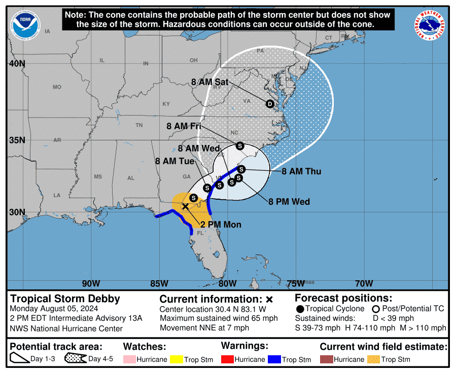
This morning, Aug. 5 Debby made landfall in Florida’s Big Bend region as a hurricane.
As of 2 p.m., Debby was now being categorized as a tropical storm, with sustained winds of 65 mph, the National Hurricane Center said. It takes winds of 75 mph and above for a storm to be classified as a hurricane.
Within the next few days, Debby is expected to move upward along the Southeast, bringing with it the potential for heavy rainfall and major flooding. To prepare residents, the NOAA has issued a high risk ― it’s highest level of flood outlook.
According to The Weather Channel, flooding from rainfall could intensify due to winds blowing onshore along the Southeast coast. In turn, this may prevent floodwaters from draining towards the ocean. Other risks posed by Debby include strong wind gusts, storm surge, and tornadoes.
Here’s what to know as the tropical storm travels to S.C.
Where is Debby now?
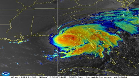
At 2 p.m. Aug. 5, Debby was currently tracking inland in northern Florida and southern Georgia, with heavy rainfall extending from the Florida Peninsula to southern Georgia and South Carolina.
A tornado watch is in effect until 4 p.m. for northern and central Florida, as well as southeast Georgia.
More: Jim Cantore is in Charleston: That’s not a good sign ahead of historic flooding forecast

In the Big Bend region, rainfall totaled 5 to 10 inches, according to The Weather Channel. Wind gusts of 60 mph were also reported, with a top gust of 70 mph near Mayo. Over in Cedar Key, a water rise of 6 feet above normal was observed, causing moderate coastal flooding. More than a foot of rainfall was reported in various spots in west-central Florida.
Where will Debby head next?
Debby will now track northeast, heading toward southern Georgia and stalling before moving through the Southeast coast over the week, according to the National Hurricane Center. Serious impacts from the storm slowing down regard rainfall flooding. Since 2013, flooding was accountable for the majority of direct U.S. deaths from tropical storms and hurricanes, per a 2023 National Hurricane Center study.
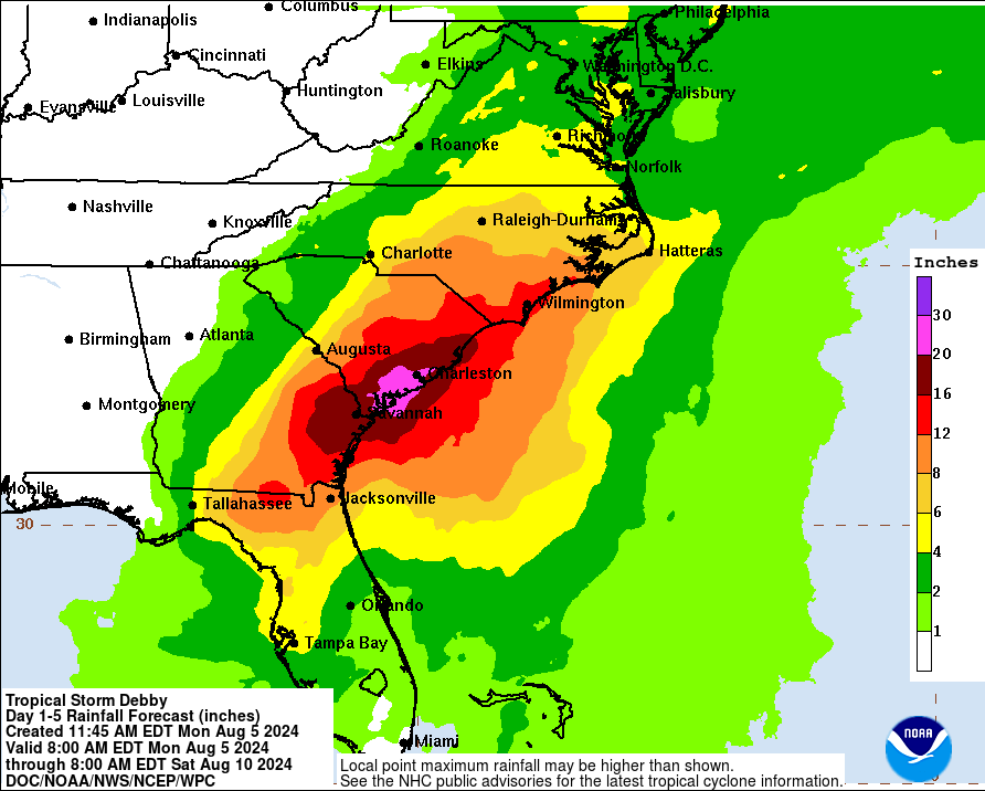
How much rainfall will SC receive?
Portions of southeast Georgia, the S.C. coastal plain, and southeast North Carolina are expected to receive rainfall totals between 10 to 20 inches. Localized amounts may reach 30 inches through Saturday morning. According to the Hurricane Center’s rainfall map, the area between Savannah, Georgia, and Charleston likely will have the heaviest impact.
“Potentially historic heavy rainfall across southeast Georgia and the coastal plain of South Carolina through Saturday morning will likely result in areas of catastrophic flooding,” the Hurricane Center said.
AccuWeather’s statement was even stronger.
“Rainfall totals could surpass 30 inches in spots. I’m very concerned the Savannah, Charleston and Myrtle Beach areas could face catastrophic amounts of rainfall over the next few days, especially if Debby stalls for a longer amount of time than we expect,” Alex DaSilva, AccuWeather Lead Hurricane Expert, said in a news release.
Parts of central and northern Florida and northeast North Carolina may have rainfall totals of 6 to 12 inches, and up to 18 inches locally.
NOAA statistics indicate that half of deaths in floods occur in vehicles. For this reason, it is important to avoid driving through flooded areas or around barriers signaling a road closure.

Flash flood watches and warnings for Georgia, SC
A flood watch remains in effect for the following areas in southeast Georgia as of 10:45 a.m.: Bulloch, Candler, Coastal Bryan, Coastal Chatham, Coastal Liberty, Coastal McIntosh, Effingham, Evans, Inland Bryan, Inland Chatham, Inland Liberty, Inland McIntosh, Jenkins, Long, Screven and Tattnall.
In southeast S.C., the following areas remain under a flood watch as of 10:45 a.m.: Allendale, Beaufort, Charleston, Coastal Colleton, Coastal Jasper, Dorchester, Hampton, Inland Berkeley, Inland Colleton, Inland Jasper and Tidal Berkeley.
Tropical storm and surge warning in effect for Georgia, SC coast
A tropical storm warning is in effect for the following areas as of 2p.m.: Florida coast from Indian Pass to Aripeka, St. Augustine, Florida to South Santee River, South Carolina.
When will Debby be in SC?
The NOAA’s tropical storm outlook states the center will move across southeastern Georgia tonight and Tuesday. By late Tuesday and Wednesday, the storm will move offshore of the SC coast.
Excessive rain outlooks over the next few days, according to The Weather Channel
∎ Monday-Monday night: northern and central Florida to southeast Georgia and southern South Carolina.
∎ Tuesday-Tuesday night: northeast Florida to eastern Georgia, middle and lower South Carolina and southern North Carolina. Lingering heavy rain might continue as far south as central Florida.
∎ Wednesday-Wednesday night: Southeast Georgia to middle and lower South Carolina, eastern North Carolina and southeast Virginia.
∎ Thursday-Friday: The threat of flooding rain might continue in parts of the Carolinas and Virginia, but details are uncertain.
Nina Tran covers trending topics for The Greenville News. Reach her via email at [email protected].
This article originally appeared on Greenville News: Tropical Storm Debby: Historic rain expected in Charleston, SC
Source Agencies