UPDATE: Hurricane Debby made landfall Monday morning as a Category 1 hurricane. Get the latest updates here. The previous story is below.
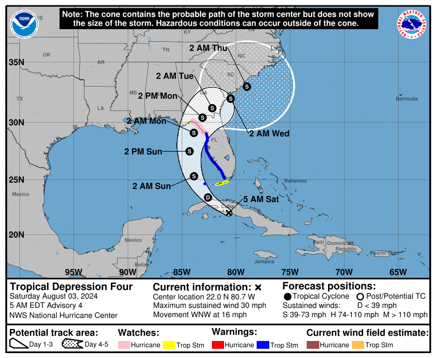
Hurricane Debby formed in the Gulf of Mexico Sunday night as it moved over the Gulf of Mexico on its way to expected landfall in the Big Bend region of North Florida where it will bring major flooding, according to the National Hurricane Center’s latest advisory.
Mandatory evacuation orders were issued for Alachua, Citrus, Dixie, Franklin, Levy, Taylor and Wakulla counties and a state of emergency is in effect for 61 of Florida’s 67 counties.
➤ Live updates: Get the latest on Hurricane Debby as it approaches Florida
➤ Spaghetti models for Hurricane Debby
The NHC warned that life-threatening storm surge is possible for portions of Florida’s Gulf Coast.
Additional strengthening of the Category 1 hurricane is expected. Winds could gust up to 85-90 mph and north Florida could see “catastrophic rain” amounts of up to 15-20 inches, Gov. Ron DeSantis said during a briefing Sunday.
A hurricane warning is in effect for a portion of Florida as warm Gulf waters fuel Debby which is expected to hit the Big Bend region on Monday.
Sustained winds were at 75 mph as of the 11 p.m. advisory.
Where is Hurricane Debby?
-
Location: 65 miles west-southwest of Cedar Key, 100 miles west-northwest of Tampa
-
Maximum sustained winds: 75 mph
-
Movement: north-northwest at 12 mph
-
Next advisory: 5 a.m. p.m. Aug. 5
Hurricane Debby expected to strengthen

At 11 p.m., the center of Hurricane Debby was located near latitude 28.6 North, longitude 84.0 West, longitude 84.1 West, according to the National Hurricane Center.
Debby is moving toward the north near 12 mph.
A gradual decrease in forward speed with a turn toward the northeast and east is expected on Monday and Tuesday.
On the forecast track, the center will move across the northeastern Gulf of Mexico tonight and reach the Florida Big Bend coast Monday morning.
Debby is then expected to move slowly across northern Florida and southern Georgia Monday and Tuesday, and be near the Georgia coast by Tuesday night.
Data from Air Force and NOAA reconnaissance aircraft indicate that maximum sustained winds have increased to near 75 mph with higher gusts.
Additional strengthening is likely before Debby reaches the Florida Big Bend coast on Monday.
Weakening is expected on Monday and Tuesday after Debby moves inland. Hurricane-force winds extend outward up to 45 miles from the center and tropical-storm-force winds extend outward up to 140 miles.
The estimated minimum central pressure is 985 mb.
Spaghetti models: Latest forecasts on where Hurricane could make Florida landfall
Special note about spaghetti models: Spaghetti model illustrations include an array of forecast tools and models, and not all are created equal. The Hurricane Center uses only the top four or five highest performing models to help make its forecasts.
Hurricane, storm surge warnings issued for Florida
A hurricane warning is in effect for:
A Hurricane Warning means that hurricane conditions are expected somewhere within the warning area. A warning is typically issued 36 hours before the anticipated first occurrence of tropical-storm-force winds, conditions that make outside preparations difficult or dangerous. Preparations to protect life and property should be rushed to completion.
A hurricane watch is in effect for:
-
Florida coast south of Yankeetown to Boca Grande
-
Florida coast from west of Indian Pass to Mexico Beach
-
Ponte Vedre Beach to South Santee River South Carolina
A hurricane watch means that hurricane conditions are possible within the watch area. A watch is typically issued 48 hours before the anticipated first occurrence of tropical-storm-force winds, conditions that make outside preparations difficult or dangerous.
A tropical storm warning is in effect for:
-
Florida coast south of Yankeetown to Boca Grande
-
Florida coast from west of Indian Pass to Mexico Beach
-
Ponte Vedre Beach to South Santee River South Carolina
A tropical storm warning means that tropical storm conditions are expected somewhere within the warning area within 36 hours.
storm watch means that tropical storm conditions are possible within the watch area, generally within 48 hours.
A storm surge warning is in effect for:
-
Florida coast from the middle of Longboat Key northward to Indian Pass including Tampa Bay
-
Georgia and South Carolina coast from the Mouth of the St. Mary’s River to South Santee River South Carolina
A Storm Surge Warning means there is a danger of life-threatening inundation, from rising water moving inland from the coastline, during the next 36 hours in the indicated locations.
A storm surge watch is in effect for:
A storm surge watch means there is a possibility of life-threatening inundation, from rising water moving inland from the coastline, in the indicated locations during the next 48 hours.
Potential impacts from Hurricane Debby
WIND: Hurricane conditions are expected in the hurricane warning area by early Monday, with tropical storm conditions beginning overnight. Tropical storm conditions will continue to spread northward over the tropical storm warning area along the Florida Gulf coast through tonight, and begin along portions of the tropical storm warning area along the Atlantic coast by late Monday. Tropical storm conditions are expected along the coast of South Carolina within the tropical storm warning area late Monday night.
STORM SURGE: The combination of storm surge and tide will cause normally dry areas near the coast to be flooded by rising waters moving inland from the shoreline. The water could reach the following heights above ground somewhere in the indicated areas if the peak surge occurs at the time of high tide:
-
Yankeetown, FL to Ochlockonee River, FL…6-10 ft
-
Chassahowitzka, FL to Yankeetown, FL…4-6 ft
-
Ochlockonee River, FL to Indian Pass, FL…4-6 ft
-
Middle of Longboat Key, FL to Chassahowitzka, FL…3-5 ft
-
Tampa Bay…3-5 ft
-
Mouth of the St. Mary’s River to South Santee River, SC…2-4 ft
-
Middle of Longboat Key, FL to Englewood, FL…2-4 ft
RAINFALL: Hurricane Debby is expected to produce rainfall totals of 6 to 12 inches, with maximum amounts of 18 inches, across portions of central and northern Florida and southeastern North Carolina through Friday morning. This rainfall will likely result in areas of considerable flash and urban flooding, with significant river flooding expected. Across portions of southeast Georgia and South Carolina, 10 to 20 inches of rainfall, with local amounts to 30 inches, are expected through Friday morning. This potentially historic rainfall will likely result in areas of catastrophic flooding.
TORNADOES: A few tornadoes are possible over central and northern Florida and southern Georgia tonight and Monday. The threat will spread northeastward into coastal Georgia and parts of South Carolina on Monday. SURF: Swells generated by Debby are expected to affect much of the Gulf coast of Florida through Monday. Swells will begin to affect the Southeast U.S. coast on Monday and continue through the middle of the week. These conditions are likely to cause life-threatening surf and rip current conditions.
Key messages on what Florida can expect from Hurricane Debby
-
Potentially historic heavy rainfall across southeast Georgia and South Carolina through Friday morning will likely result in areas of catastrophic flooding. Heavy rainfall will likely result in considerable flooding impacts from portions of central and northern Florida through the Coastal Plain of the Carolinas through Friday.
-
There is a danger of life-threatening storm surge along portions of the Gulf Coast of Florida, with 6 to 10 feet of inundation above ground level expected somewhere between Ochlockonee River to Yankeetown late tonight and Monday morning. Residents in the Storm Surge Warning area should follow any advice given by local officials.
-
Hurricane conditions are expected Monday along portions of the Florida Big Bend region where a Hurricane Warning is in effect, with tropical storm conditions beginning this evening. Tropical storm conditions are expected through Monday farther south within the Tropical Storm Warning area along Florida’s west coast, including the Tampa Bay area.
-
Dangerous storm surge and wind impacts are expected along portions of the southeast U.S. coast from northeastern Florida to North Carolina through the middle of the week, and storm surge warnings and tropical storm watches and warnings have been issued for portions of these areas.
Mandatory evacuations ordered for Florida counties
Evacuation orders are in place for the following (zone map):
MANDATORY EVACUATION ORDERS
-
Citrus County
-
Evacuation Order: Mandatory
-
Evacuation Info: Voluntary evacuation for all low-lying areas and anyone residing in campers, tents, mobile homes, manufactured homes, or any structure not capable of withstanding sustained winds up to 60 mph. Mandatory Zone A
-
Dixie County
-
Evacuation Order: Mandatory
-
Evacuation Info: Evacuations will begin at 2 p.m. on Sunday, August 4, 2024, and be for the following: All coastal communities including Suwannee, Horseshoe Beach, Jena and the immediate surrounding areas, all substandard housing, low-lying areas in the county.
-
Franklin County
-
Evacuation Order: Mandatory
-
Evacuation Info: Mandatory evacuation for all barrier island (St. George Island, Dog Island and Alligator Point), low lying and flood prone areas especially along the coast and rivers, and RV parks effective 6:00 a.m., Sunday, August 4, 2024. Additional evacuations may be issued if there are changes in storm track or intensity.
-
Levy County
-
Evacuation Order: Mandatory
-
Evacuation Info: Mandatory evacuation, to commence immediately and be completed by 8 p.m. on Saturday, August 3, 2024, of persons residing in recreational vehicle parks throughout the County, and to the maximum extent possible, the recreational vehicles shall be removed from the County; mobile homes and manufactured homes throughout the County; coastal communities in the County; and low-Iying areas throughout the County.
-
Taylor County
-
Evacuation Order: Mandatory
-
Evacuation Info: The Taylor County Sheriff’s Office has issued a volunteer evacuation order for all coastal and low lying areas. We have strongly encouraged coastal residents to evacuate. We do not use the term Mandatory due to not being able to force people from their homes legally. The Taylor County Elementary School shelter located at 1600 East Green street will be open at 4pm today. Please bring only essential items due to limited space. Pets are allowed but must be in a crate.
VOLUNTARY EVACUATION ORDERS
-
Clay County
-
Gadsden County
-
Hamilton County
-
Hernando County
-
Jefferson County
-
Lafayette County
-
Madison County
-
Pasco County
-
Union County
Weather watches and warnings issued in Florida
Major flooding expected in Florida: Excessive rainfall forecast
River flooding: Real-time Florida river water levels
Florida Gov. DeSantis issues state of emergency for 61 counties
Florida is monitoring Invest 97L in the Atlantic, which is expected to strengthen and potentially make landfall as early as this weekend. It will be slow-moving and bring lots of rain that could cause significant flooding.
I encourage all residents to prepare for the storm and…
— Ron DeSantis (@GovRonDeSantis) August 1, 2024
Gov. Ron DeSantis issued a state of emergency Thursday for 54 counties in preparation for the potential landfall of a storm that could become the first “significant threat” to the state.
Friday night, he added another seven counties. That brings 61 of the state’s 67 counties under a state of emergency.
When is the Atlantic hurricane season?
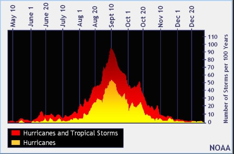
The Atlantic hurricane season runs from June 1 through Nov. 30.
When is the peak of hurricane season?


The peak of the season is Sept. 10, with the most activity happening between mid-August and mid-October, according to the Hurricane Center.
National Hurricane Center map: What are forecasters watching now?
Systems currently being monitored by the National Hurricane Center include:


In addition to Hurricane Debby, the National Hurricane is monitoring a tropical wave.
The wave, located a couple of hundred miles east of the Windward Islands continues to produce an area of showers and thunderstorms, and earlier satellite wind data showed winds of 30 to 35 mph just north of the wave axis. Environmental conditions appear generally favorable for some slow development over the next week while the system moves quickly westward at around 20 mph, crossing the Windward Islands Monday morning and moving into the central and western Caribbean by the middle to latter part of this week.
Formation chance through 48 hours: low…10 percent.
Formation chance through 7 days: low…30 percent.
Interactive map: Hurricanes, tropical storms that have passed near your city
What’s next?
We will continue to update our tropical weather coverage daily. Download your local site’s app to ensure you’re always connected to the news. And look for our special subscription offers here.
This article originally appeared on Fort Myers News-Press: Tropics update: Category 1 Hurricane Debby forms. Track FL impact, path
Source Agencies


