Tropical Storm Debby should continue to spin off South Carolina’s coast, possibly gaining strength, before coming ashore again late Wednesday or early Thursday and beginning its trek toward North Carolina, forecasters say.
On Wednesday morning, the storm’s center was about 50 miles southeast of Charleston, S.C., and moving to the northeast at about 4 mph, just a little faster than the average healthy adult walks. Debby had maximum sustained winds of around 60 mph, the National Hurricane Center said.
Once the storm makes its second landfall, forecasters say it should pick up some speed for the trip north. It should arrive in North Carolina on Thursday afternoon or evening, according to forecasts.

What will Debby bring to North Carolina?
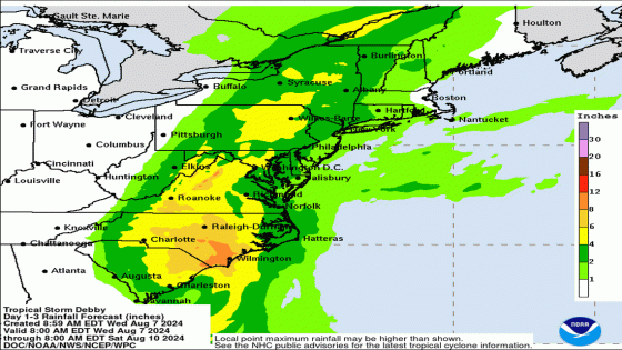
Tropical Storm Debby continues to be mainly a flooding threat, and the storm is expected to drop an additional 3 to 9 inches of rain over parts of North Carolina through Friday. That would bring the totals for the week up to 15 inches in some parts of southeastern N.C., the Hurricane Center said.
A flood watch is in effect in parts of Robeson, Bladen, Columbus, Pender, Brunswick and New Hanover counties through Friday.
A tropical storm warning and storm surge watch are in effect in coastal Brunswick County. And parts of Pender and New Hanover counties are under tropical storm warnings.
Once the storm moves inland again, forecasters expect it to track through the center of the state head into Virginia. The center of the storm should be out of North Carolina early Friday, but the back side of the storm will continue to produce rain and wind here through Friday night.

Where will flooding be the worst?
NC FIMAN — Flood Inundation Mapping and Alert Network — showed six spots in eastern and southeastern N.C. Wednesday where major flooding is expected during or after Debby’s rains, plus more than a dozen sites where moderate or mild flooding is expected. FIMAN uses stream flow data, weather forecasts and other information to identify places where flooding will occur.
As they have been in the past, low-lying areas along the Neuse River are expected to flood in Clayton, Smithfield, Goldsboro and Clinton, along with ones on the Lumber River in Lumberton, the Little River in Spring Lake and the Cape Fear River in Fayetteville and Wilmington.
Most of central North Carolina is under a flood watch through Friday, and flash flooding is expected in low-lying areas and those in urban areas that don’t drain quickly.

What’s the forecast for Raleigh?
The Triangle can expect another 4 to 8 inches of rain through late Friday before the storm moves out. Wednesday and Thursday will be the wettest days.
▪ Wednesday is likely to bring some showers, but heavier storms are expected Wednesday night that could bring 2 to 3 inches of rain.
▪ Thursday and Thursday night, showers are likely and thunderstorms are possible, with the potential for a total of up to 5 inches of rain throughout the day. Winds will be around 15 mph with gusts as high as 26 mph, the National Weather Service says.
▪ Friday and Friday night will likely bring more showers and possibly a thunderstorm, with considerably less accumulation — less than 1 inch total. It will still be breezy with gusts up to 24 mph, forecasters say.
▪ Saturday should be mostly sunny and hot, with a high of 89, the Weather Service says.
Source Agencies