Article first published: Monday, Aug. 12, 2024, 5 a.m. ET
Article last updated: Monday, Aug. 12, 2024, 11 a.m. ET
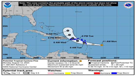
According to the National Hurricane Center’s 11 am Monday advisory, the potential tropical cyclone is 435 miles east-southeast of Antigua and 730 miles east-southeast of San Juan Puerto Rico, with maximum sustained wind of 35 mph. It’s moving 26 mph to the west. Forecasters announced a tropical storm warning for the Virgin Islands and Puerto Rico.
YESTERDAY (Sunday):
The National Hurricane Center released the first advisory for a potential tropical cyclone at 5 pm yesterday (Sunday). Forecasters issued a tropical storm watch for portions of the leeward islands.
CHANGES WITH THIS ADVISORY:
The Tropical Storm Watch for the U.S. Virgin Islands and Puerto Rico, including Vieques and Culebra, has been upgraded to a Tropical Storm Warning.
The government of Antigua has upgraded the Tropical Storm Watch to a Tropical Storm Warning for the British Virgin Islands.
SUMMARY OF WATCHES AND WARNINGS IN EFFECT:
A Tropical Storm Warning is in effect for:
– St. Kitts, Nevis, Montserrat, Antigua, Barbuda, and Anguilla
– Guadeloupe
– St. Martin and St. Barthelemy
– Sint Maarten
– British Virgin Islands
– U.S. Virgin Islands
– Puerto Rico
– Vieques
– Culebra
A Tropical Storm Warning means that tropical storm conditions are expected somewhere within the warning area within 36 hours.
Interests elsewhere in the northeastern Caribbean should monitor the progress of Potential Tropical Cyclone Five.
For storm information specific to your area in the United States,
HAZARDS AFFECTING LAND:
RAINFALL: Potential Tropical Cyclone Five is expected to produce total rain accumulations of 4 to 6 inches over portions of the Leeward and Virgin Islands. For Puerto Rico, 3 to 6 inches of rainfall, with maximum amounts of 10 inches, is expected. Elsewhere in the Caribbean, Potential Tropical Cyclone Five is expected to produce the following rain accumulations through Friday morning: Windward Islands…1 to 4 inches Eastern Hispaniola…2 to 4 inches For a complete depiction of forecast rainfall associated with Potential Tropical Cyclone Five, please see the National Weather Service Storm Total Rainfall Graphic, available at hurricanes.gov/graphics_at5.shtml? Rainqpf
WIND: Tropical storm conditions are expected in the warning area for the Leeward Islands beginning late tonight or Tuesday. Tropical storm conditions are expected to begin spreading over the Virgin Islands and Puerto Rico on Tuesday night or early Wednesday.
STORM SURGE: A storm surge will raise water levels by as much as 1 to 3 feet above ground level for the eastern coast of Puerto Rico from San Juan to Guayama, including the islands of Culebra and Vieques and in the U.S. Virgin Islands, including St. Thomas, St. John, and St. Croix.
A storm surge will raise water levels by as much as 1 to 3 feet above normal tide levels in the British Virgin Islands. Near the coast, the surge will be accompanied by large and destructive waves.
SURF: Swells generated by the system will likely begin to affect portions of the Leeward Islands beginning tonight. These swells are likely to cause life-threatening surf and rip current conditions.
Source: National Hurricane Center
This article was generated by the Sun Herald Bot, artificial intelligence software that analyzes information from the National Hurricane Center and applies it to templates created by journalists in the newsroom. We are experimenting with this and other new ways of providing more useful content to our readers and subscribers. You can report errors or bugs to [email protected]. Full hurricane coverage at sunherald.com/news/weather-news/
Source Agencies