While Hurricane Ernesto is expected to stay well away from Florida and the United States, don’t let your guard down, especially if you’re making beach plans.
Ernesto is expected to become a major hurricane before the center passes over or near Bermuda Saturday, according to the National Hurricane Center.
➤ Weather alerts via text: Sign up to get updates about current storms and weather events by location
A major hurricane is one with sustained winds of at least 111 mph, making it a Category 3 storm or higher.
The U.S. isn’t expected to feel any direct impacts from the hurricane but dangerous beach conditions, including life-threatening rip currents, are in the forecast starting Thursday and lasting through the weekend along the East Coast.
Hurricane Ernesto: What you need to know

Watches, warnings issued across Florida
A high rip current risk has already been issued for some areas of Florida’s coast, lasting until Sunday evening, according to the National Weather Service.
Impacts: What can Florida, US East Coast expect from Hurricane Ernesto?
The only impact the U.S. can expect from Hurricane Ernesto are marine impacts, including swells affecting the coast and beach erosion, but the biggest impact will be a significant risk for rip currents, said Adam Douty, AccuWeather senior meteorologist.
Timeline: See when beach conditions will deteriorate from Hurricane Ernesto
The impacts will start in the south and spread north starting Thursday.
“For Florida and a lot of the Southeast Coast (of the U.S.) swells will pick up late today (Thursday) and more so tonight. By the time you wake up Friday morning, swells from Ernesto will be seen from Florida to the Outer Banks,” Douty said in a telephone interview.
“Through Friday, Virginia Beach to the Jersey shore will see swells arrive, and by the end of the day Long Island will see increasing surf.
“Friday, Saturday and Sunday we’ll see dangerous beach conditions, although for the Northeast, those conditions won’t start until Saturday.”
Expect dangerous beach conditions to last through the entire weekend, Douty said.
Stay informed. Get weather alerts via text
What are swells and why are they dangerous?
Swells are those rolling waves offshore, Douty said. “They can be fairly dangerous. The move more water than typical wind waves, and when more water moves in, more water moves out. That causes more dangerous rip currents.
“Generally, we’re looking 3- to 6-foot swell heights and 4- to 8-foot swells at the highest.”
Why are rip currents ‘life-threatening’?
“Even strong swimmers can be overwhelmed by rip currents,” Douty said.
“Water is a very powerful thing. Once you’re in a rip current, it’s too late to do anything except to ride it out. You’re never going to win a battle of swimming against it. You’ll wear yourself out competing against it.
Best advice? “If you’re going to venture into the water, do so at a beach with a lifeguard. Heed flags and don’t enter the surf if it’s too dangerous,” Douty said.
“If caught in a rip current, relax and float. Don‘t swim against the current. If able, swim in a direction following the shoreline. If unable to escape, face the shore and call or wave for help,” the National Weather Service Jacksonville said.
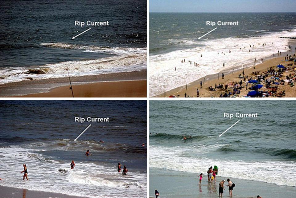
What does a rip current look like?


Before you even go near the water, check the conditions. There are several ways.
-
Check the forecast. The National Weather Service issues rip current statements or you can check current Florida rip current risks at weather.gov/beach/florida.
-
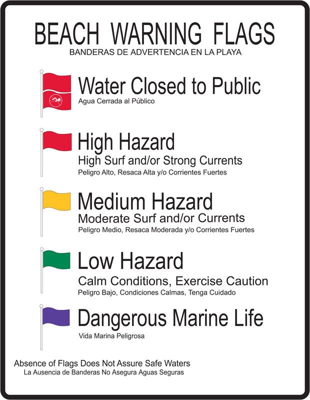
At the beach, look for warning flags at beach approaches or lifeguard station. Red flags mean dangerous rip current activity is expected. Double red flags mean the water is closed to the public.
-
Ask a lifeguard. Don’t be shy, any lifeguard would be happy to let you know if it’s dangerous to go in the water.
-
Stand back where you can see the ocean’s surface and check for visible gaps of darker, flat spots in lines of breaking waves; a channel of churning, choppy water; a difference in water color; or a line of foam, seaweed or debris moving back toward the sea. But rip currents can be subtle and hard to identify, according to NOAA.
What do the beach warning flags mean?


Watch for beach warning flags at lifeguard towers, stations and other locations for a heads-up on current conditions and potential dangers.
-
Double red flags mean the water is closed to the public.
-
A red flag is high hazard, meaning high surf and/or strong currents.
-
A yellow flag is medium hazard, meaning moderate surf and/or currents.
-
A green flag is low hazard, meaning calm conditions, exercise caution.
-
A purple flag means that dangerous marine life spotted.
This article originally appeared on Treasure Coast Newspapers: Hurricane Ernesto bringing Florida beach dangers, rip currents
Source Agencies


