Article first published: Monday, July 01, 2024, 5 a.m. ET
Article last updated: Tuesday, July 02, 2024, 2 a.m. ET
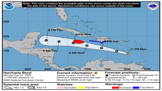
On Tuesday at 2 am, the National Hurricane Center issued an advisory stating that system transformed into a Category 4 hurricane. It later upgraded to a Category 5 hurricane with sustained winds of 160 miles per hour. Category 5 Hurricane Beryl’s journey: it developed in the Atlantic Ocean, made its way to the Caribbean Sea.
Category 5 Hurricane Beryl is 445 miles east-southeast of Isla Beata Dominican Republic and 775 miles east-southeast of Kingston Jamaica, with maximum sustained wind of 165 mph. It’s moving 22 mph to the west-northwest.
“Beryl is forecast to continue moving rapidly west-northwestward during the next couple of days. On the forecast track, the center of Beryl will move quickly across the southeastern and central Caribbean Sea today and is forecast to pass near Jamaica on Wednesday. Fluctuations in strength are likely during the next day or so, but Beryl is expected to still be near major hurricane intensity as its moves into the central Caribbean and passes near Jamaica on Wednesday.” forecasters explained. “Additional weakening is expected thereafter, though Beryl is forecast to remain a hurricane in the northwestern Caribbean.”
SUMMARY OF WATCHES AND WARNINGS IN EFFECT:
A Hurricane Warning is in effect for:
– Jamaica
A Tropical Storm Warning is in effect for:
– South coast of Dominican Republic from Punta Palenque westward to the border with Haiti
– South coast of Haiti from the border with the Dominican Republic to Anse d’Hainault
A Hurricane Warning means that hurricane conditions are expected somewhere within the warning area. A warning is typically issued 36 hours before the anticipated first occurrence of tropical-storm-force winds, conditions that make outside preparations difficult or dangerous.
A Tropical Storm Warning means that tropical storm conditions are expected somewhere within the warning area within 36 hours.
Interests elsewhere in the the Cayman Islands, and the remainder of the northwestern Caribbean should closely monitor the progress of Beryl. Additional watches or warnings may be required later today.
HAZARDS AFFECTING LAND:
WIND: Hurricane conditions are expected to reach the coast on Jamaica within the warning area on Wednesday. Winds are expected to first reach tropical storm strength early on Wednesday, making outside preparations difficult or dangerous.
Tropical storm conditions are expected in the warning area along the south coast of Hispaniola later today.
STORM SURGE: Storm surge could raise water levels by as much as 3 to 5 feet above normal tide levels in areas of onshore winds along the immediate coast of Jamaica.
Storm surge could raise water levels by as much as 1 to 3 feet above ground level in areas of onshore winds along the southern coast of Hispaniola.
RAINFALL: Hurricane Beryl is expected to produce rainfall totals of 4 to 8 inches, with localized maxima of 12 inches, in portions of Jamaica on Wednesday. This rainfall may cause flash flooding in vulnerable areas. Rainfall from outer bands of Beryl may impact portions of Hispaniola today into Wednesday, with 2 to 6 inches of rain possible.
For a complete depiction of forecast rainfall and flash flooding associated with Hurricane Beryl, please see the National Weather Service Storm Total Rainfall Graphic, available at hurricanes.gov/graphics_at2.shtml? Rainqpf
SURF: Large swells generated by Beryl will continue across the Windward and southern Leeward Islands during the next couple of days. Swells are also expected to reach the southern coasts of Puerto Rico and Hispaniola later today. These swells are expected to cause life-threatening surf and rip current conditions.
Source: National Hurricane Center
This article was generated by the Miami Herald Bot, artificial intelligence software that analyzes information from the National Hurricane Center and applies it to templates created by journalists in the newsroom. We are experimenting with this and other new ways of providing more useful content to our readers and subscribers. You can report errors or bugs to [email protected]. Full hurricane coverage at miamiherald.com/news/weather/hurricane/
Source Agencies