A tropical depression could form by early next week as a disturbance moves west across the Atlantic, according to the latest advisory from the National Hurricane Center.
It’s not totally unexpected. Forecasters have been warning tropical activity is expected to increase as Saharan dust in the atmosphere dissipates.
➤ Weather alerts via text: Sign up to get updates about current storms and weather events by location
August, a month when tropical cyclone activity begins to pick up, has been fairly quiet, prompting AccuWeather forecasters to revise — sort of — earlier predictions for the number of named storms this season.
“AccuWeather hurricane experts now assess that 20-23 named storms are most likely,” said AccuWeather Chief Meteorologist Jon Porter.
Before you get too excited about the slightly lower numbers, Porter said, “While a total of 20-23 named storms is most likely, we cannot yet rule out 24 or 25 storms” that have been predicted previously.
“The reason for this assessment is the long lull that has been experienced in recent weeks where there have been no named storms during what is typically a very active time of the hurricane season.”
‘Don’t let your guard down’ when it comes to the tropics
Meteorologists have warned residents to not let their guard down when it comes to storms in the Atlantic basin.
AccuWeather forecasters are predicting “a major shift in the weather pattern will soon blow the doors wide open for a frenzy of tropical activity to unfold.” We might be seeing the beginning of that shift.
“I think things could get very active potentially very quickly here as soon as that dry air — Saharan dust — goes away,” AccuWeather Lead Hurricane Expert Alex DaSilva said.
“We could see a parade of storms. This dramatic increase in activity will start at the end of August and persist throughout September,” AccuWeather said. Labor Day 2024 is on Sept. 2.
Between six and 10 tropical systems are predicted for September, according to AccuWeather meteorologists. That’s similar to the pace of the record-breaking 2020 hurricane season which had 10 September storms. The same year saw a record 30 named storms in the season.
The next named storm of the 2024 Atlantic hurricane season will be Francine.
Florida forecast: Could tropical activity affect your Labor Day plans?
A disturbance in the eastern Atlantic that appeared on the National Hurricane Center’s tropical outlook map Tuesday is expected to consolidate over the Labor Day weekend as it approaches the Lesser Antilles, DaSilva said.
Sometime between Saturday and Labor Day on Monday is when it could become a tropical depression or storm, DaSilva said.
Don’t expect any impacts to Florida or the U.S. over the Labor Day weekend, DaSilva said.
At the earliest, Florida or the U.S. could feel impacts from the system the following weekend, around Sept. 7 or so. But that’s a very, very early prediction and a lot can change before then.
“It’s still very far from potential U.S. impacts as it moves across the Atlantic,” DaSilva said.
A tropical wave that evolves quickly is more likely to turn northwest sooner and possibly track near the northern islands of the Caribbean, according to AccuWeather. A system that remains weak may continue west longer and may get into the western part of the Caribbean rather than turn up east of Florida.
Watch out for rapid intensification of tropical storms and hurricanes

“I’m still very concerned over rapid intensification. We saw it with Beryl. Now, during the peak of season, if anything gets into Gulf (of Mexico) I would be very nervous and concerned,” DaSilva said.
“I’ve never seen the Gulf this warm before. If something gets into the Gulf, it can’t get out until it hits land.”
Water temperatures in the Gulf of Mexico are in the mid to upper 80s. A temperature of 80 degrees is the minimum needed for tropical cyclones, providing plenty of energy for storms to form and quickly strengthen, DaSilva said.
Where do storms usually form this time of year?
“This time of year, typically it’s harder to get storms to form closer to home, in the Gulf of Mexico, Caribbean or off the East Coast of Florida and the U.S. Tropical waves mostly come off Africa,” providing plenty of time for meteorologists and residents to track the systems and be prepared.
That doesn’t mean something couldn’t pop up closer to the U.S. and that’s what happened Wednesday morning, with a new tropical disturbance appearing well east of Florida.
“It wouldn’t to take much for something to develop, but this time of year we more commonly see tropical waves moving west across the Atlantic or off the southeast coast, especially given the warm water temperatures. Typically at this time of year, though, most storms originate much farther east in the Atlantic.
That’s not the case in October, especially toward the end of the month, when tropical systems tend to develop closer to the U.S., DaSilva said.
Here’s the latest update from the NHC as of 8 a.m. Aug. 29:
What is out there and how likely are they to strengthen?
The National Hurricane Center was monitoring one tropical disturbance in the Atlantic basin, according to the 8 a.m. advisory. The Atlantic basin consists of the northern Atlantic Ocean, Caribbean Sea and Gulf of Mexico.


Tropical disturbance 1: A tropical wave over the central tropical Atlantic Ocean is producing some disorganized showers and thunderstorms.
Environmental conditions appear conducive for gradual development of this system, and a tropical depression could form by early next week while it moves westward at 10 to 15 mph and approaches the Lesser Antilles.
The system is then forecast to move westward to west-northwestward across portions of the eastern Caribbean Sea during the middle part of next week.
-
Formation chance through 48 hours: low, near 0 percent.
-
Formation chance through 7 days: medium, 40 percent.
What does the colored area on the NOAA map mean?
The hatched areas on a tropical outlook map indicate “areas where a tropical cyclone — which could be a tropical depression, tropical storm or hurricane — could develop,” said National Hurricane Center Deputy Director Jamie Rhome.
The colors make it visibly clear how likely a system could develop with yellow being low, orange medium and red high.
The National Hurricane Center generally doesn’t issue tropical advisories until a there is a named storm, but there is an exception.
“If a system is near land and there is potential for development, the National Hurricane Center won’t wait before it issues advisories, even if the system hasn’t become an actual storm. This gives residents time to prepare,” Rhome said.
Who is likely to be impacted?
It’s too early at this time to determine if there will be any impact to Florida or the U.S. from the disturbance.
Forecasters urge all residents to continue monitoring the tropics and to always be prepared. That advice is particularly important for what is expected to be a very active hurricane season.
Need hurricane supplies? Save now during Florida tax holiday
The second and final two-week period to save on hurricane supplies started Aug. 24 and runs through Sept. 6.
With the 2024 Atlantic hurricane season not only expected to busy — some predict more than double the average of 14 named storms — but also to last well into November, now it the time to purchase supplies. Once a storm approaches, a run on stores begins and shelves are stripped bare of essentials.
What hurricane supplies are tax free in Florida?


-
A portable generator used to provide light or communications or preserve food in the event of a power outage with a sales price of $3,000 or less.
-
A tarpaulin or other flexible waterproof sheeting with a sales price of $100 or less.
-
An item normally sold as, or generally advertised as, a ground anchor system or tie-down kitwith a sales price of $100 or less.
-
A smoke detector or smoke alarm with a sales price of $70 or less.
-
A fire extinguisher with a sales price of $70 or less.
-
A carbon monoxide detector with a sales price of $70 or less.
-
A nonelectric food storage cooler with a sales price of $60 or less.
-
A portable power bank with a sales price of $60 or less.
-
A gas or diesel fuel tank with a sales price of $50 or less.
-
A portable self-powered radio, two-way radio, or weather-band radio with a sales price of$50 or less.
-
A package of AA-cell, AAA-cell, C-cell, D-cell, 6-volt, or 9-volt batteries, excluding automobileand boat batteries, with a sales price of $50 or less.
-
A portable self-powered light source (powered by battery, solar, hand-crank, or gas) with asales price of $40 or less.
-
Flashlights
-
Reusable ice (ice packs) with a sales price of $20 or less.
-
Lanterns
-
Candles
➤ Do you need a generator? With active hurricane season ahead, do you need a generator in Florida? Here’s how to decide
➤ How to prepare for hurricane season: On a budget? Here are 5 cheap ways to prepare your home for Florida’s hurricane season
Expect to see new ‘cone of concern’ with next named storm, if it nears Florida, US
The National Hurricane Center launched its new “cone of concern” for Hurricane Ernesto on Aug. 14.
Ernesto stayed well away from Florida and the U.S., so residents didn’t see many differences between the original and new cone. One of the biggest differences between the two is that the new cone will show wind warnings issued for interior counties, not just those on the coast.
Both cones will be visible on the Hurricane Center’s website. Find the new cone by going to the graphics page for the storm, then click on “New Experimental Cone,” which will be highlighted in red.
Differences you’ll see:
-
Watches and warnings for inland counties, not just coastal areas.
-
White transparent shading for the entire five-day forecast, instead of white stippling (dots) for the four- and five-day forecast.
Weather watches and warnings issued in Florida
Stay informed. Get weather alerts via text
When is the Atlantic hurricane season?
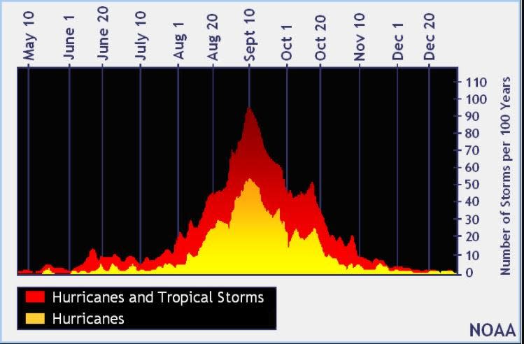
The Atlantic hurricane season runs from June 1 through Nov. 30.
When is the peak of hurricane season?


The peak of the season is Sept. 10, with the most activity happening between mid-August and mid-October, according to the Hurricane Center.
National Hurricane Center map: What are forecasters watching now?
Systems currently being monitored by the National Hurricane Center include:


Interactive map: Hurricanes, tropical storms that have passed near your city
Excessive rainfall forecast
What’s next?
We will continue to update our tropical weather coverage daily. Download your local site’s app to ensure you’re always connected to the news. And look for our special subscription offers here.
This article originally appeared on Treasure Coast Newspapers: Tropics update: NHC tracking potential tropical depression
Source Agencies


