BATON ROUGE, La. (BRPROUD) — After a short lull in tropical activity in the Atlantic Basin once Ernesto dissipated, the tropics are looking more active with the National Hurricane Center (NHC) now watching three disturbances for possible development over the next week.
Two of the tropical waves are in the Central and Eastern Atlantic while the other disturbance is in the Northwestern Gulf of Mexico. The Gulf disturbance will bring some impacts to portions of Texas and Louisiana, including the Greater Baton Rouge area. The two waves out in the Atlantic will have to be watched very closely through the next week as well.

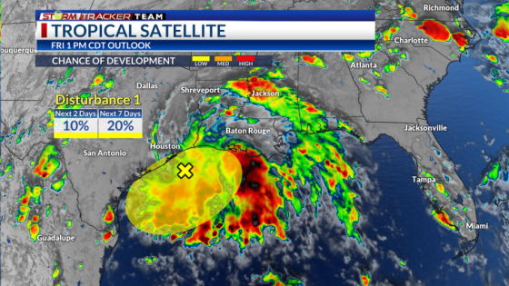
Gulf Disturbance
The NHC is giving a large area of lower pressure with disorganized showers and storms in the Northwestern Gulf a low chance of development (10 percent chance over two days and 20 percent chance over 7 days) for a tropical system to form.
The disturbance will meander near the Gulf Coast through the weekend into the new work week where slow development is a lower possibility if it stays over water. This will keep rain chances high for portions of Texas and Louisiana along with a risk for flash flooding from heavy rainfall.

Regardless of whether it is a named storm or not, heavy rainfall appears to be the main threat. Average rainfall totals over the next 7 days look to range from 1-2″ over Southwest Mississippi and 2-3″ over the Baton Rouge area with 7″+ along the extreme coastline. It is important to know that locally higher amounts will be possible with any training rain bands that set up over certain areas.

The main threat for flash flooding would be from heavy rain in these bands that could overwhelm drainage systems for urban and low-lying areas. A Flood Watch is in effect for parishes along and south of the 10/12 corridors through 7 PM Saturday.

Is Louisiana ready for hurricane season? Report shows how prepared state is
Central Atlantic Disturbance
A tropical wave in the Central Tropical Atlantic is producing disorganized showers and storms currently. However, the NHC gives this wave a medium chance (40 percent) for gradual development over the next 7 days.
This wave will likely move westwards toward the Lesser Antilles after the weekend before entering the Caribbean where a tropical depression is possible by mid-week. From there, movement into the Western Caribbean is likely.

While it is well too far out to talk about a specific track for this potential system, it seems a path to the Greater Antilles, the Gulf or Central America could all be possible. Make sure to keep an eye on the tropics as there is plenty of time to monitor.
Eastern Atlantic Disturbance
Another tropical wave is just off of the coast of Africa with a few disorganized showers and storms. There is a low chance for some slow development (20 percent) over the next 7 days as the system moves generally north-northwest.

Thanks for signing up!
Watch for us in your inbox.
Subscribe Now
Latest News
Copyright 2024 Nexstar Media, Inc. All rights reserved. This material may not be published, broadcast, rewritten, or redistributed.
For the latest news, weather, sports, and streaming video, head to BRProud.com.
Source Agencies