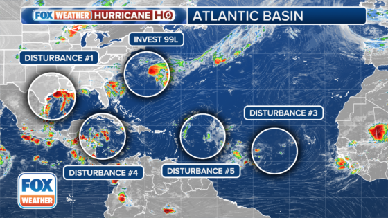
MIAMI – Forecasters with the National Hurricane Center (NHC) are keeping an eye on five tropical disturbances swirling in the Atlantic Basin, including a newly designated Invest 99L off the U.S. East Coast.
An “invest” is simply a naming convention used by the NHC in Miami, the Central Pacific Hurricane Center (CPHC) in Honolulu, Hawaii, and the U.S. Joint Typhoon Warning Center (JTWC) in Pearl Harbor, Hawaii, to identify areas they are investigating for possible development into a tropical depression or tropical storm within the next seven days.
The NHC said Invest 99L is located a few hundred miles east of North Carolina and is producing showers and thunderstorms to the northeast and east of the system’s center.
Invest 99L could acquire some subtropical characteristics over the next few days while it moves to the north-northeast.
Invest 99L is expected to remain off the Northeast coast, and once the system moves over cooler waters by late Saturday, further subtropical development is not expected.
The NHC is giving Invest 99L a low chance of developing.
DOWNLOAD THE FREE FOX WEATHER APP
An area of disturbed weather off the Texas and Louisiana coasts in the Gulf of Mexico is again being monitored for possible tropical development over the next few days.
This area of disturbed weather has been blasting the Gulf Coast with heavy rain over the past several days, but the NHC dropped development odds earlier this week.
However, in its update on Thursday morning, the NHC once again said it would watch the system.
The NHC said upper-level winds are expected to become less conducive for development by Friday and Saturday as a front approaches ther area.
“Although development is unlikely, heavy rainfall is expected across portions of the northern Gulf Coast over the next day or so,” the NHC said.
The NHC is giving the system a low chance of developing.
A tropical disturbance is moving quickly to the west at about 20 mph over the western Caribbean and is continuing to produce a broad area of disorganized showers and thunderstorms.
The NHC says some development of this system is possible in the next few days after the system moves across Mexico‘s Yucatán Peninsula and then into the southwestern Gulf of Mexico. The system has been given a low chance of developing over the next week.
SUMMER WEATHER RECAP: WHO BAKED IN THE HEAT AND WHO ESCAPED THE FRYING PAN?
A tropical disturbance over the eastern tropical Atlantic is producing a broad area of disorganized showers and thunderstorms. The NHC said slow development is possible over the next several days while the system drifts off to the northwest or north.
The disturbance has a low chance of developing over the next week.
A tropical disturbance located several hundred miles east of the Lesser Antilles is continuing to produce an area of disorganized precipitation and thunderstorms. The NHC said strong upper-level winds are expected to limit the development of the system as it moves west-northwest.
The NHC said environmental conditions could become more conducive to slow development by early next week as the system moves to the northwest over the southwestern Atlantic. The system has a low chance of developing over the next seven days.
SEPTEMBER TO MAKE OR BREAK ROBUST HURRICANE SEASON OUTLOOKS
Original article source: Invest 99L off East Coast among 5 tropical disturbances monitored for development in Atlantic, Gulf of Mexico
Source Agencies