Hurricane Francine made landfall in Louisiana on Wednesday, delivering strong winds, storm surge and flooding from Louisiana across the Mississippi Coast. Here’s a look at scenes across both states as Francine continues its trek northward.
South Mississippi


Was a little windy and wet tonight in Biloxi Mississippi as Francine passed to the west. Waves were crashing on the side of 90 as well. Biloxi Pd was having to barricade parts of 90 due to coastal flooding. #mswx #Francine pic.twitter.com/ASj0spJ9QI
— Ryan Cartee (@dixiealleychsr) September 12, 2024
Mississippi
RIGHT NOW: What’s left of Francine is passing through the Jackson area this morning. Flash flooding has left this road underwater in the heart of the city. I’m reporting live on @accuweather with what I’m seeing in Mississippi. ️️ pic.twitter.com/e2wrR3oMGd
— Emmy Victor (@EmmyReports) September 12, 2024
Francine is set to roll through west of Starkville as a Tropical Depression, with greatest impacts being felt from 3-11 AM. Impacts associated with the storm are: wind gusts 30-45 MPH, few storms, and 3-4 inches of rain w flooding possible. #mswx @MSUWeather pic.twitter.com/0k0AfhvpmL
— Mitchell Keyes (@mitchellkeyeswx) September 11, 2024
Louisiana
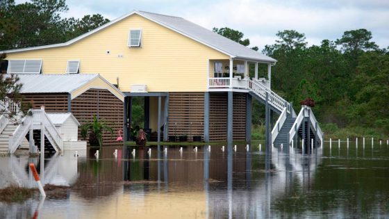
Here’s a look at some of what we are seeing in Lafourche Parish after Hurricane Francine. The curfew remains in effect until 10am.
The parish says they know of at least 12 homes that took on water. Waiting for sunrise for further assessments. @WWLTV pic.twitter.com/7hnA0KERYh— Leigha McNeil WWL (@leigha_mcneil) September 12, 2024
As for the power grid, it’s … not good for our friends to the West.
It’s not all bad, though. Our New Orleans friends retain their sense of humor.
Alabama and beyond
Source Agencies