As North and South Carolina brace for heavy wind, rain, potential floods and tornadoes Monday, the News Leader reached out to Alex DaSilva, AccuWeather lead hurricane expert, to find out what the Shenandoah Valley can expect as Potential Tropical Cyclone Eight moves into Virginia.
The good news is things are trending a little bit less rainy in the Shenandoah Valley as of Monday, said DaSilva. Overall, it does not look like the area will see any significant impact from the storm.
“It’s more like 1-2 inches total from the storm in the Shenandoah Valley, the higher terrain, the mountains will probably get more,” said DaSilva. “Eastern and southern portions of the state, that’s where you will see more rain like 2-4 inch range.”
It also doesn’t look like there’s going to be a whole lot of wind in the area either, he added. There could be some gusts up to 30 mph, but overall, things have trended down.
While residents need to be mindful of possible localized ponding and flooding, said DaSilva, given the moderate-to-severe drought in the Valley, especially in Augusta County, most will probably welcome the rain.
“Tuesday afternoon into Tuesday night will be the heaviest rain. Wednesday it will start to taper off,” said DaSilva. “I think the rain is going to be mostly beneficial. There could be some gusty winds in some of those rain bands.”
More: 35th annual African-American Heritage & Multicultural Festival happening this weekend
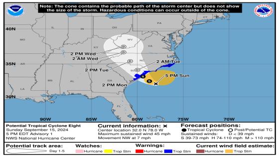
The storm is less organized to be considered a tropical storm or given a name, said DaSilva.
“You need winds 39 mph or greater of sustained winds and a defined center of circulation. The wind is there. The wind is absolutely there at 50 mph in Wrightsville Beach in North Carolina,” said DaSilva around 11 a.m. Monday, but there is no defined center of circulation.
That can still happen before it makes landfill Monday afternoon, he added. If the storm’s center of circulation becomes defined, it will be named Tropical Storm Helene.

National Weather Service forecast
Monday
Mostly cloudy, with a high near 71. Northeast wind around 10 mph.
Monday night
Showers likely, mainly after 5 a.m. Cloudy, with a low around 61. Northeast wind around 8 mph, with gusts as high as 20 mph. Chance of precipitation is 60%. New precipitation amounts between a tenth and quarter of an inch possible.
Tuesday
Showers and possibly a thunderstorm. High near 68. Northeast wind around 11 mph, with gusts as high as 22 mph. Chance of precipitation is 80%. New rainfall amounts between a half and three quarters of an inch possible.
Tuesday night
Showers likely and possibly a thunderstorm before 2 a.m., then a chance of showers and thunderstorms after 2 a.m. Cloudy, with a low around 62. Northeast wind 7 to 10 mph, with gusts as high as 21 mph. Chance of precipitation is 60%. New rainfall amounts between a quarter and half of an inch possible.
Wednesday
A chance of showers, with thunderstorms also possible after 2 p.m. Mostly cloudy, with a high near 71. Northeast wind around 7 mph. Chance of precipitation is 50%.
More: Athlete of the week: Vote for who had the best week in Staunton, Augusta County and Waynesboro
Wednesday night
A chance of showers and thunderstorms. Mostly cloudy, with a low around 61. Chance of precipitation is 30%.
Thursday
A chance of showers. Mostly cloudy, with a high near 74. Chance of precipitation is 40%.
Thursday night
Mostly cloudy, with a low around 60.
Friday
A chance of showers after 2 p.m. Partly sunny, with a high near 75. Chance of precipitation is 30%.
Friday night
A chance of showers before 8 p.m. Partly cloudy, with a low around 58. Chance of precipitation is 30%.
This article originally appeared on Staunton News Leader: AccuWeather tropical storm forecast for Shenandoah Valley, Virginia
Source Agencies