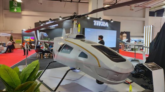
Turkish drone-maker Titra is teaming with aerospace specialist Airbus to modify the ALPIN drone so it can operate from naval platforms as well as take off and land autonomously, the former announced this week.
The unmanned helicopter was first used during Turkish operations in the northern region of Iraq, Titraâs chief executive Abdulkadir Sener told reporters during a homeland security expo taking place in Ankara, Turkey, from May 21 to May 23. He said the Turkish government and other countries have requested the platform for use by naval forces.
The strategic cooperation agreement between the Turkish and French firms calls for collaboration in integrating Airbusâ DeckFinder positioning system with the ALPIN.
âWithin the scope of this cooperation, we have taken the first step towards the integration of Airbus Deck Finder and the ALPIN Unmanned Helicopter System. As a result of this cooperation, the fully autonomous landing and take-off capability of all rotary wing aerial vehicles, especially ALPIN developed by TiTRA, to moving naval platforms will be made more precise and safer with Airbus Deck Finder,â Titra announced on its social media accounts.
The ALPIN should be able to land on a moving vessel within the next six months, Sener said. And following this work, there could be opportunities for the two companies to cooperate on other projects, the executive added.
The long-range drone is designed for both military and civilian use, including rescue missions. Its design is based on the crewed Italian-made Helisport CH-7 ultralight helicopter. Development of the ALPIN began in 2019 when Titra signed a deal with UAVOS, a drone specialist with offices in the U.S., Canada and Spain. Under the agreement, Titra and UAVOS planned to convert CH-7s into dual-purpose, rotary-wing unmanned aircraft. The ALPIN made its first flight in 2020.
The ALPIN is 7 meters long, 1.5 meters wide and 2.35 meters high. Its rotor diameter is 6.28 meters.
When empty, its weigh is 340 kilograms. It can carry a maximum payload of 200 kilograms, including fuel.
The unmanned helicopter can carrying multiple payloads and transmit real-time information to operators. It features a wideband satellite communication channel for remote operations, a fully redundant autopilot system, autonomous takeoff-and-landing capabilities, a remote ground control network, and an autorotation landing capability.
Airbusâ DeckFinder is a local positioning system that allows crewed and remotely piloted aerial vehicles to determine their relative position in harsh environmental conditions. It provides a 3D image of the platformâs relative position, aiding in safe landings in environments that lack reference points or visual cues. This technology is crucial for landing on small or moving helicopter decks, where even minor deviations can endanger the mission.
Tayfun Ozberk is a Turkey correspondent for Defense News.
Source Agencies


