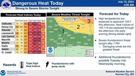
Kansas City residents are in for a scorcher Monday as temperatures will soar to the highest they have been so far this year, according to the National Weather Service.
When the humidity is factored in, the heat index values will range from 105 to as high as 115 degrees, the weather service warned.
“These heat indices will be capable of yielding heat-related illnesses in short order,” the weather service cautioned in its forecast discussion. People who must be outside during the afternoon and evening were urged to take precautions.
The temperature was expected to soar to 100 degrees in the metro. Typically, Kansas City sees temperatures of 88 degrees this time of year. If temps climb that high, it will be the first time the metro has seen temperatures this hot this year.
Kansas City’s heat index is expected to peak at 110 degrees around 3 p.m. It will remain quite hot during the evening, as the heat index is expected to be 100 degrees at 9 p.m.
The Kansas City area remains under a heat advisory until 8 p.m. People are advised to drink plenty of fluids, stay in air-conditioned rooms, stay out of the sun and check up on relatives and neighbors.
Severe weather possible in KC
Thunderstorms are expected to fire up along a cold front over central Iowa Monday afternoon. As they move to the southeast in the afternoon and evening, they will likely grow into a complex of thunderstorms.
Uncertainty remains on how these storms will develop, but storms could enter northern Missouri by late evening and overnight. There is a severe weather threat after 7 p.m. mainly in northern Missouri.
The weather service said damaging winds are the main threat, but a brief tornado can’t be ruled out.
Additional showers and thunderstorms could develop along the stalled cold front closer to the Kansas City area around Tuesday morning’s rush hour.
Tuesday’s temperatures will be slightly cooler but remain quite warm. They are expected to be around 90 degrees, with the heat index near 100 degrees.
Additional thunderstorms are possible Tuesday into Wednesday morning as the cold front continues to work south. The front, however, is expected to stall between Interstate 70 and the Ozarks, leading to the possibility of heavy rainfall in some areas.

When will cooler weather roll in?
The weather service said cooler and drier air would come behind the front. This would be a welcomed reprieve from the heat.
Temperatures will be in the lower to mid-80s on Wednesday. And the 80-degree weather will be coupled with less humidity by Thursday and Friday. Dew points will be in the mid- to upper 50s, “making it feel quite comfortable.”
The weather service said temperatures will remain in the low to mid-80s, with dew points increasing by a few degrees over the weekend.
Source Agencies