TAMPA, Fla. (WFLA) — The path of a tropical wave that could develop near Florida in the next week remained unclear on Thursday.
The National Hurricane Center is tracking a disturbance producing a large area of disorganized showers and thunderstorms over Hispaniola, Puerto Rico and the Virgin Islands.

The large swath of storms is not expected to organize over the next few days, as it interacts with land while passing over the islands. From there, it’s forecast to enter the Gulf.
“The forecast models take a weak circulation into the eastern Gulf of Mexico this weekend. After that, there’s not much agreement,” Max Defender 8 Meteorologist Leigh Spann said.
NHC forecasters said a tropical depression could form in the Gulf near Florida. Regardless of development, the state will likely see some rain late this weekend and early next week.
“At this point, expect enhanced rain chances across Florida starting Sunday and continuing into the first part of next week,” Spann said. “The forecast position and intensity of the system is still uncertain, and it will continue to change as the system organizes.”
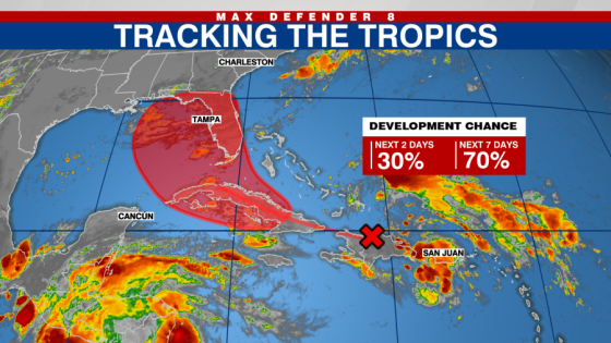
The tropical wave has a 30% chance of development in the next two days and a 70% chance of organizing in the next seven days.
Watch Tracking the Tropics on Tuesdays at 12:30 p.m. ET/11:30 a.m. CT.
Be prepared with the 2024 Hurricane Guide and stay ahead of tropical development with the Tracking the Tropics newsletter.
Copyright 2024 Nexstar Media, Inc. All rights reserved. This material may not be published, broadcast, rewritten, or redistributed.
For the latest news, weather, sports, and streaming video, head to WFLA.
Source Agencies