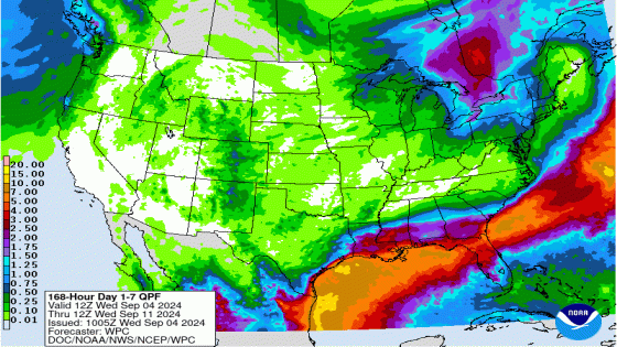
After a rainy and hot Labor Day weekend, more rain is in store for much of Florida over the next week. Lots, and lots of rain.
The storms that drenched Texas over the Labor Day weekend are drifting west along the Gulf Coast, bringing an “active and wet weather pattern” for Florida’s Panhandle and North Florida over the next few days, according to the Florida Department of Emergency Management.
Six to 10 inches of rain are possible across the coastal Panhandle and west Big Bend area over the next five days, and some areas could see more than 12 inches, the state agency said.
➤ Weather alerts via text: Sign up to get updates about current storms and weather events by location
Expect multiple days of heavy rainfall with scattered to numerous showers and thunderstorms. Flash flooding through Saturday are possible across portions of the Panhandle and North Florida.
The rest of Florida can expect typical, daily summertime thunderstorms, with locally strong to severe thunderstorms possible during the hottest portions of the day. Heat advisories may be issued for portions of South Florida starting midweek.
“Regardless of tropical organization, the storm will spread torrential rainfall eastward this week as it creeps along,” AccuWeather said.
“A general 2-4 inches of rain will fall with local amounts to 8 inches possible. Motorists along the Interstate 10 corridor from eastern Texas to Florida should be prepared for downpours.”
Weather alerts issued in Florida
What’s the weather forecast for Florida over the coming days?

Expect downpours along the central Gulf Coast Thursday, especially from Louisiana to the Florida Panhandle, AccuWeather said.
From Friday to Saturday, the main heavy rain zone will focus on northern Florida, the southern portions of Alabama and Georgia and the South Carolina coast.
Breakdown of Florida weather coming up as provided by the Florida Department of Emergency Management:
Panhandle and North Florida: A surge of moisture will gradually move northward from the Gulf of Mexico and toward the Gulf Coast and the Panhandle on Thursday and inland toward the I-10 corridor on Friday. There’s a 70% to 85% chance for scattered to numerous thunderstorms.
Any thunderstorm activity that develops may be capable of producing frequent lightning, gusty winds of 40 to 50 mph and heavy downpours. Flash flooding is possible. The active weather pattern will continue into the weekend as a front continues to stall along the northern Peninsula and near the I-10 corridor
An area of non-tropical low pressure is forecast to develop along the frontal boundary along the northern gulf coast then gradually move eastward to northeastward across the Florida Panhandle and Big Bend.Computer model guidance will continue to be monitored over the next couple of days regarding where the potential low develops and its movement through the weekend.
Florida Peninsula: On Thursday, a slight pattern change will allow for showers and thunderstorms will develop along the West Coast and move inland then collide with the East Coast sea breeze. A pocket of Saharan Dry air will attempt to bring slightly drier conditions along portions of Southeast Florida, but the overall summertime thunderstorm pattern can be expected to continue through the weekend.
Portions of South Florida could see more scattered shower and thunderstorm activity with the help of slightly drier air while the rest of the Peninsula will see scattered to numerous shower and thunderstorm activity.
Any thunderstorm could become locally strong to severe during the peak heating hours of the day. Thunderstorms will be capable of producing frequent lightning, gusty winds (40-50 mph) and heavy downpours.
Warm and muggy conditions can be expected each day as high temperatures will remain in the low to middle 90s with heat index values in the triple digits (100-108-degrees). Portions of South Florida could see heat index values reaching near or at Heat Advisory criteria beginning Wednesday and continuing into the weekend (105 degrees and higher).
Florida weather radar: Track storms

Stay informed. Get weather alerts via text

A wet pattern sets up today through the end of the work week. Expect rainfall of 2″ to 2.5″ to move into the area Wednesday and continue through Friday, the National Weather Service, Mobile said.
Depending on where the heavier rain sets up, localized flooding issues cannot be ruled out. Temperatures will be 10 to 15 degrees below normal.
-
Thursday: Showers and possibly a thunderstorm. High near 82. East wind around 15 mph, with gusts as high as 20 mph. Chance of precipitation is 80%. New rainfall amounts between a tenth and quarter of an inch, except higher amounts possible in thunderstorms.
-
Friday: Showers and possibly a thunderstorm. High near 80. East wind 10 to 15 mph. Chance of precipitation is 80%.
-
Saturday: A 50 percent chance of showers and thunderstorms. Mostly cloudy, with a high near 81. North wind 10 to 15 mph, with gusts as high as 20 mph.
-
Sunday: A slight chance of showers, with thunderstorms also possible after 1pm. Mostly sunny, with a high near 83. Northeast wind 10 to 15 mph, with gusts as high as 20 mph. Chance of precipitation is 20%.
Follow National Weather Service Mobile on X, formerly known as Twitter
Moist air will move over the region Thursday through Friday night, bringing more than 2.5″ of rain. Depending on several environmental factors, widespread showers and storms are possible Friday and Saturday, according to the National Weather Service Tallahassee.
Expect temps to gradually warm back up Saturday and Sunday, with daytime highs in the mid and upper 80s with overnight lows generally in the mid 60s to the north and low 70s closer to the coast.
-
Thursday: Showers and thunderstorms likely, mainly after 2 p.m. Mostly cloudy, with a high near 85. East northeast wind 5 to 10 mph. Chance of precipitation is 70%. New rainfall amounts between a tenth and quarter of an inch, except higher amounts possible in thunderstorms.
-
Friday: Showers and thunderstorms, mainly after 2 p.m. High near 83. East wind around 5 mph. Chance of precipitation is 80%.
-
Saturday: Showers and thunderstorms likely. Mostly cloudy, with a high near 80. Chance of precipitation is 70%.
-
Sunday: A 40 percent chance of showers and thunderstorms, mainly after 8 a.m. Partly sunny, with a high near 84.
Follow the National Weather Service Tallahassee on X, formerly known as Twitter
Forecasts for Northeast Florida through Friday evening over the next 3 days are for 2 to 6 inches of rainfall, with the higher values toward Atlantic coast and St. Johns River basin. The rain will bring a threat for localized flooding, along with the potential for waterspouts, according to the National Weather Service Jacksonville.
Expect more “unsettled” weather over the weekend as a system of low pressure moves from the Gulf Coast to the Atlantic.
-
Thursday: Showers and possibly a thunderstorm. High near 85. Northeast wind 8 to 13 mph, with gusts as high as 20 mph. Chance of precipitation is 90%. New rainfall amounts between a quarter and half of an inch possible.
-
Friday: A chance of showers and thunderstorms, then showers and possibly a thunderstorm after 8 a.m. High near 84. Northeast wind 6 to 8 mph. Chance of precipitation is 80%.
-
Saturday: Showers and thunderstorms. High near 82. Chance of precipitation is 80%.
-
Sunday: Showers and thunderstorms likely, mainly after 2 p.m. Mostly cloudy, with a high near 84. Chance of precipitation is 70%.
Follow the National Weather Service Jacksonville on X, formerly known as Twitter

Scattered to numerous showers and lightning storms are forecast each afternoon. Heavy rainfall, cloud to ground lightning, and gusty winds will remain the primary threats. Heat and humidity will produce peak heat index values 102 to 106, according to the National Weather Service, Melbourne.
At least a moderate risk of dangerous rip currents is expected to continue at the beaches into next week.
-
Thursday: A chance of showers and thunderstorms, then showers likely and possibly a thunderstorm after 2 p.m. Partly sunny, with a high near 89. Heat index values as high as 102. East wind 5 to 10 mph. Chance of precipitation is 70%. New rainfall amounts between a quarter and half of an inch possible.
-
Friday: A chance of showers and thunderstorms, then showers likely and possibly a thunderstorm after 2 p.m. Partly sunny, with a high near 88. South wind 5 to 10 mph becoming east in the afternoon. Chance of precipitation is 70%.
-
Saturday: A chance of showers and thunderstorms, then showers likely and possibly a thunderstorm after 2 p.m. Partly sunny, with a high near 90. Southwest wind 5 to 10 mph. Chance of precipitation is 70%.
-
Sunday: A chance of showers and thunderstorms, then showers likely and possibly a thunderstorm after 2 p.m. Partly sunny, with a high near 88. West wind 5 to 10 mph becoming north northeast in the afternoon. Chance of precipitation is 70%.
Follow the National Weather Service Melbourne on X, formerly known as Twitter
Scattered to numerous showers and lightning storms are forecast each afternoon. Heavy rainfall, cloud to ground lightning, and gusty winds will remain the primary threats. Heat and humidity will produce peak heat index values 102 to 106, according to the National Weather Service, Melbourne.
At least a moderate risk of dangerous rip currents is expected to continue at the beaches into next week.
-
Thursday: A chance of showers and thunderstorms, then showers likely and possibly a thunderstorm after 2 p.m. Mostly sunny, with a high near 90. Heat index values as high as 103. East wind 5 to 10 mph. Chance of precipitation is 60%. New rainfall amounts of less than a tenth of an inch, except higher amounts possible in thunderstorms.
-
Friday: A chance of showers and thunderstorms, then showers likely and possibly a thunderstorm after 2 p.m. Partly sunny, with a high near 90. East southeast wind 5 to 10 mph. Chance of precipitation is 60%.
-
Saturday: A chance of showers and thunderstorms, then showers likely and possibly a thunderstorm after 2 p.m. Mostly sunny, with a high near 92. South southwest wind 5 to 10 mph. Chance of precipitation is 60%.
-
Sunday: A chance of showers and thunderstorms, then showers likely and possibly a thunderstorm after 2 p.m. Mostly sunny, with a high near 92. South southwest wind 5 to 10 mph becoming southeast in the afternoon. Chance of precipitation is 60%.
Follow the National Weather Service Melbourne on X, formerly known as Twitter

The forecast for Thursday night through Tuesday calls for “typical conditions for late summer in South Florida, with warm temperatures and afternoon showers and thunderstorms each day,” according to the National Weather Service Miami. By the end of the weekend, temperatures should cool off a bit.
Expect overnight and early morning showers along the East Coast metro areas. Rainfall amounts should be around 2 inches.
Temperatures will be a bit more seasonable during this period, with highs in the upper 80s to low 90s, and peak heat index values around 100-107.
-
Thursday: A 30 percent chance of showers and thunderstorms, mainly after 11 a.m. Mostly sunny, with a high near 87. Heat index values as high as 103. Southeast wind 11 to 13 mph.
-
Friday: A 40 percent chance of showers and thunderstorms, mainly after 2 p.m. Mostly sunny, with a high near 87. Southeast wind 8 to 10 mph.
-
Saturday: A 40 percent chance of showers and thunderstorms after 2 p.m. Mostly sunny, with a high near 87. Southeast wind 8 to 10 mph.
-
Sunday: A 40 percent chance of showers and thunderstorms, mainly after 2 p.m. Mostly sunny, with a high near 88. Southeast wind 7 to 10 mph.
Follow the National Weather Service Miami on X, formerly known as Twitter
The forecast for Thursday night through Tuesday calls for “typical conditions for late summer in South Florida, with warm temperatures and afternoon showers and thunderstorms each day,” according to the National Weather Service Miami. By the end of the weekend, temperatures should cool off a bit.
Expect scattered to numerous showers and storms from late morning to afternoon focused over the interior and Gulf Coast. Rainfall amounts should be around 2 inches.
Temperatures will be a bit more seasonable during this period, with highs in the upper 80s to low 90s, and peak heat index values around 100-107.
-
Thursday: A 50 percent chance of showers and thunderstorms after 2 p.m. Mostly sunny, with a high near 93. Heat index values as high as 109. East wind 8 to 10 mph becoming south in the afternoon. New rainfall amounts of less than a tenth of an inch, except higher amounts possible in thunderstorms.
-
Friday: A 40 percent chance of showers and thunderstorms after 2 p.m. Mostly sunny, with a high near 91. East wind 6 to 8 mph becoming south in the afternoon.
-
Saturday: A 40 percent chance of showers and thunderstorms after 2 p.m. Mostly sunny, with a high near 90. Southeast wind 6 to 9 mph becoming southwest in the afternoon.
-
Sunday: A 40 percent chance of showers and thunderstorms after 2 p.m. Mostly sunny, with a high near 91. Southeast wind 6 to 8 mph becoming southwest in the afternoon.
Follow the National Weather Service Miami on X, formerly known as Twitter

-
Thursday: Showers likely and possibly a thunderstorm after 2 p.m. Mostly sunny, with a high near 93. Heat index values as high as 109. East southeast wind 6 to 8 mph. Chance of precipitation is 60%. New rainfall amounts between a quarter and half of an inch possible.
-
Friday: Scattered showers and thunderstorms after 2 p.m. Mostly sunny, with a high near 93. East wind 5 to 7 mph becoming south in the afternoon. Chance of precipitation is 50%.
-
Saturday: Scattered showers and thunderstorms after 2 p.m. Mostly sunny, with a high near 91. Southeast wind 5 to 7 mph becoming southwest in the afternoon. Chance of precipitation is 50%.
-
Sunday: Scattered showers and thunderstorms after 2 p.m. Mostly sunny, with a high near 91. Light and variable wind becoming south southwest 5 to 7 mph in the morning. Chance of precipitation is 50%.
Follow the National Weather Service Tampa Bay on X, formerly known as Twitter
-
Thursday: Isolated showers and thunderstorms, then showers likely and possibly a thunderstorm after 2 p.m. Mostly sunny, with a high near 92. Heat index values as high as 112. East wind around 10 mph. Chance of precipitation is 60%. New rainfall amounts between a tenth and quarter of an inch, except higher amounts possible in thunderstorms.
-
Friday: Scattered showers and thunderstorms after 2 p.m. Mostly sunny, with a high near 90. East southeast wind around 9 mph becoming south southwest in the afternoon. Chance of precipitation is 50%.
-
Saturday: Scattered showers and thunderstorms after 8 a.m. Mostly sunny, with a high near 90. South southeast wind 8 to 11 mph. Chance of precipitation is 50%.
-
Sunday: Scattered showers and thunderstorms, then showers likely and possibly a thunderstorm after 2 p.m. Mostly sunny, with a high near 90. Southeast wind 7 to 9 mph becoming southwest in the afternoon. Chance of precipitation is 60%.
Follow the National Weather Service Tampa Bay on X, formerly known as Twitter
This article originally appeared on Treasure Coast Newspapers: Florida weather forecast, radar: 6-12 inches rain, Panhandle, Big Bend
Source Agencies