(This story was updated to add new information.)
In a hurry? Here’s what’s happening with Hurricane Helene in less than a minute. Want more details?
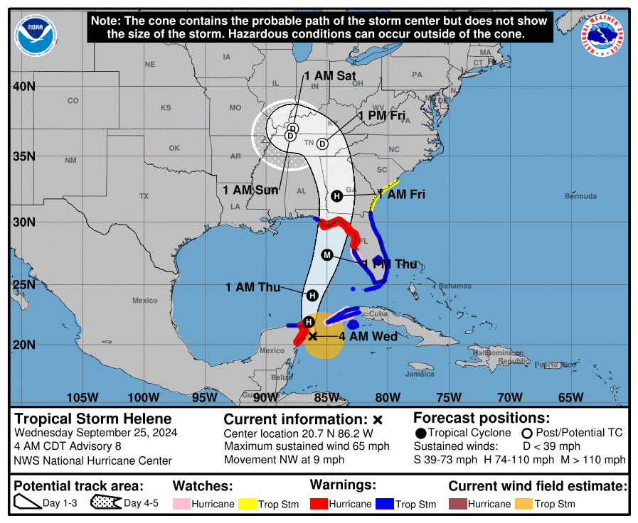
Hurricane Helene continued to strengthen Wednesday night, with predictions of winds at 130 mph sometime Thursday. At 11 p.m. EDT, winds were at 85 mph, according to the latest National Hurricane Center update.
Forecasters are predicting Helene could be a Category 4 hurricane with winds topping 130 before it makes landfall in Florida. Potential storm surges in the Big Bend area are forecast to be up to 18-20 feet above ground.
The National Hurricane Center predicted “catastrophic and life-threatening flash and urban flooding.” Evacuation orders have been issued along some areas of the Gulf Coast.
Helene is expected to weaken after it makes landfall, but forecasters warn that its fast forward speed will allow strong winds to penetrate well inland.
➤ Spaghetti models for Tropical Storm Helene
➤ Weather alerts via text: Sign up to get updates about current storms and weather events by location
Experts are urging residents to prepare for this large storm, which could bring several life-threatening impacts not only to Florida but hundreds of miles away from where it makes landfall. Dangerous storm surge, flooding rainfall, destructive winds and a threat for tornadoes are all possible.
Landfall currently is predicted to take place along Florida’s Big Bend.
Spaghetti models for Hurricane Helene
Special note about spaghetti models: Illustrations include an array of forecast tools and models, and not all are created equal. The Hurricane Center uses only the top four or five highest performing models to help make its forecasts.
➤ Spaghetti models for Hurricane Helene
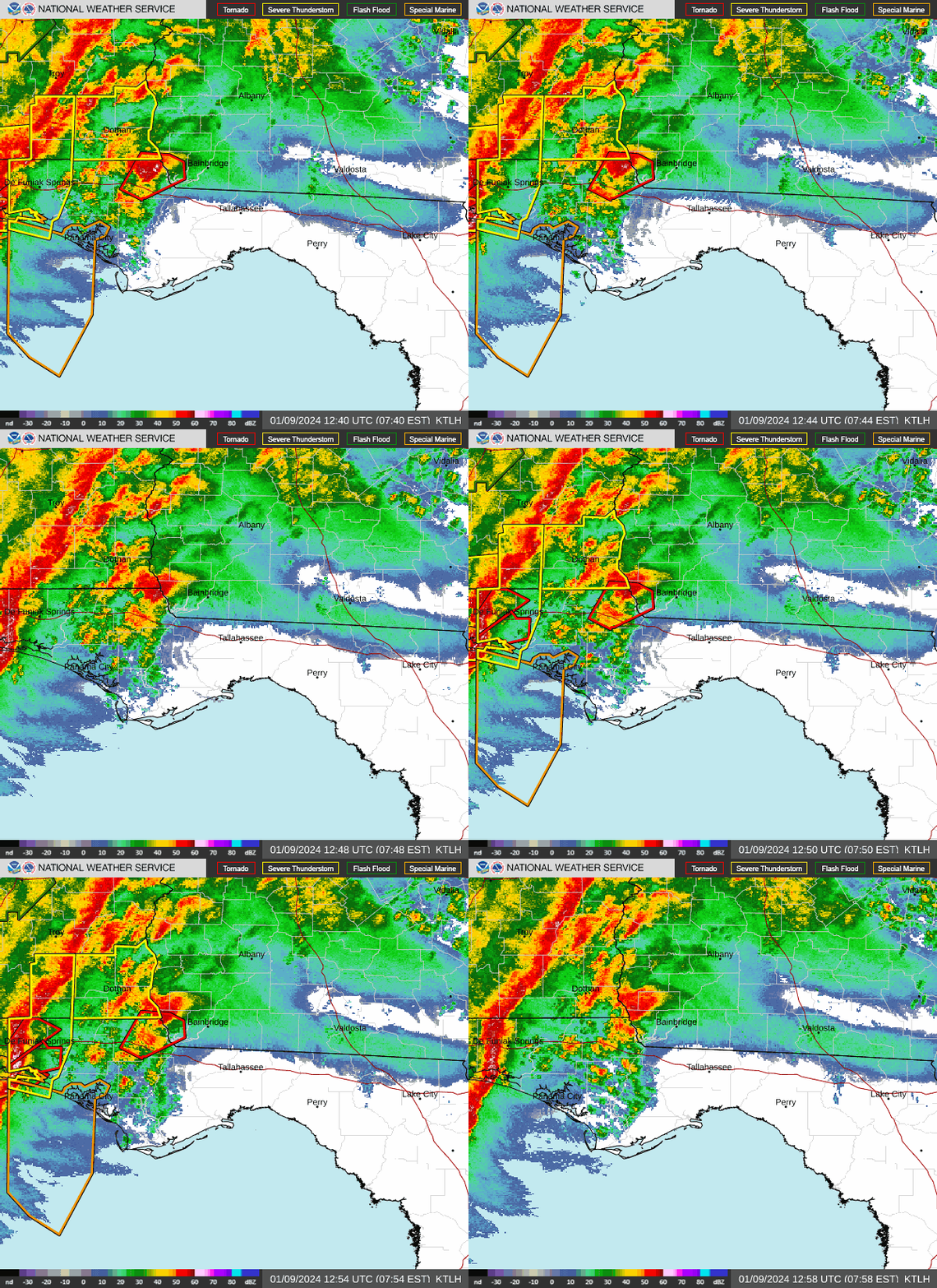
Radar images of Hurricane Helene

Hurricane Helene: What you need to know


See latest models, graphics, radar images of Hurricane Helene
When could Tallahassee, Florida, feel impacts from tropical system?


“Confidence is increasing for potentially significant impacts across our region including high winds, significant and life-threatening storm surge in Apalachee Bay, flash flooding from heavy rainfall, and a few tornadoes,” the National Weather Service Tallahassee said.
“It is increasingly likely that a major hurricane will make landfall somewhere along the FL Big Bend coast on Thursday. While exact impacts will be heavily dependent on the eventual track, expect catastrophic wind damage near the eventual landfall point and inland along the track.
➤ WeatherTiger breaks down Helene’s track, impacts
“Widespread and prolonged power outages, downed tees and powerlines, inaccessibility due to blocked roads, and damage to structures will all be possible, particularly close to and east of the track.
“There is a danger of life-threatening storm surge for Apalachee Bay. Storm surge may begin to arrive as early as late Wednesday night ahead of the winds,” the National Weather Service Tallahassee said.
“This forecast, if realized, is a nightmare surge scenario for Apalachee Bay. Please, please, please take any evacuation orders seriously!
“Heavy rainfall is possible ahead of Helene Wednesday, perhaps enhancing the overall flooding threat on Thursday as Helene moves through the area. Even though the hurricane is forecast to be moving quickly, very high rainfall rates and already saturated soils in some places will still combine for a serious flood risk across the region.
“A few tornadoes will be possible along and east of the eventual track.”
Could impacts from Helene be felt in Southwest Florida?


Widespread tropical impacts are expected across West-Central and Southwest Florida beginning tonight and Thursday, according to the National Weather Service Tampa Bay. Expected impacts include:
-
Life threatening storm surge is expected Thursday and Friday. Potential peak surge amounts are
-
Carrabelle, FL to Suwannee River, FL…15-20 ft
-
Apalachicola, FL to Carrabelle, FL…10-15 ft
-
Suwannee River, FL to Chassahowitzka, FL…10-15 ft
-
Chassahowitzka, FL to Anclote River, FL…8-12 ft
-
Indian Pass, FL to Apalachicola, FL…6-10 ft
-
Anclote River, FL to Middle of Longboat Key, FL…5-8 ft
-
Tampa Bay…5-8 ft
-
Middle of Longboat Key, FL to Englewood, FL…4-7 ft
-
East of Mexico Beach, FL to Indian Pass, FL…3-5 ft
-
Englewood, FL to Flamingo, FL…3-5 ft
-
Charlotte Harbor…3-5 ft
-
-
Flooding rain threat will run from this evening through this weekend with rainfall amounts of 6 to 12 inches with locally higher amounts up to 18 inches possible. Even after Helene pulls away, additional rounds of heavy rainfall are expected this weekend.
-
Hurricane conditions are expected within the U.S. hurricane warning area late Thursday, with tropical storm conditions beginning Thursday morning. Tropical storm conditions are expected in southern Florida tonight and will spread northward across the rest of Florida, Georgia, and South Carolina through Thursday night.
-
A tornado or two may occur tonight over parts of Florida. The risk for tornadoes will increase on Thursday, expanding northward across Florida into parts of Georgia and South Carolina.
Weather radar for Tallahassee, Florida


Weather radar for Florida West Coast, Sarasota
What impacts are possible in Florida from Hurricane Helene?
Wind. “Wind gusts frequenting 100-140 mph are forecast near and just to the east of where Helene lands, with an AccuWeather Local StormMax wind gust of 160 mph,” forecasters predicted.
Rain. “Near where Helene makes landfall, general rainfall of 8-12 inches is forecast, with an AccuWeather Local StormMax rainfall of 24 inches.”
Storm surge. “A storm surge of 15-20 feet is anticipated near and just east of where the eye rolls ashore. At this time, the level of storm surge is most likely in the Big Bend area of Florida. However, a significant storm surge of 6 to perhaps 10 feet will occur through the Tampa area and perhaps as far to the west as Panama City, Florida, depending on the hurricane track,” according to AccuWeather.
Tornadoes. A few tornadoes are possible.
Power outages. Widespread power outages are anticipated north and east of where the eye makes landfall.
Watches, warnings issued across Florida
Florida Gov. Ron DeSantis declares state of emergency
Gov. Ron DeSantis has declared a state of emergency for 41 of Florida’s 67 counties in advance of “Potential Tropical Cyclone Nine,” according to an executive order released Monday.
➤ Florida won’t escape this one. Prepare for major hurricane.
Tuesday morning, he increased the number of counties to 61.
Counties under the state of emergency are: Alachua, Baker, Bay, Bradford, Brevard, Calhoun, Charlotte, Citrus, Clay, Collier, Columbia, DeSoto, Dixie, Duval, Escambia, Flagler, Franklin, Gadsden, Gilchrist, Glades, Gulf, Hamilton, Hardee, Hendry, Hernando, Highlands, Hillsborough, Holmes, Jackson, Jefferson, Lafayette, Lake, Lee, Leon, Levy, Liberty, Madison, Manatee, Marion, Monroe, Nassau, Okaloosa, Okeechobee, Orange, Osceola, Pasco, Pinellas, Polk, Putnam, Santa Rosa, Sarasota, Seminole, St. Johns, Sumter, Suwannee, Taylor, Union, Volusia, Wakulla, Walton, and Washington counties.
Stay informed. Get weather alerts via text
What’s next?
We will continue to update our tropical weather coverage daily. Download your local site’s app to ensure you’re always connected to the news. And look for our special subscription offers here.
This article originally appeared on Tallahassee Democrat: Spaghetti models, radar Hurricane Helene. Florida impact, landfall
Source Agencies

