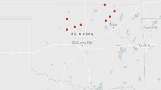
At least eight tornadoes were reported to have made landfall in parts of the southern and central United States on Monday evening, as millions of people in the region braced for a rare severe weather threat, forecasters said, warning of the potential for flash flooding and destructive hail.
Four of the tornadoes were reported to have touched down in Oklahoma, one in Tennessee, two in South Dakota and one in Nebraska, David Hamrick, a meteorologist with the Weather Prediction Center said Monday. The extent of the damage was unclear, he added, but more severe weather, including possible tornadoes, were expected.
There were reports of damage in Washington County, Okla., after a tornado near State Highway 123, the county’s emergency management officials said. The National Weather Service issued a rare tornado emergency, which warns of catastrophic damage and severe threat to human life, for about 30 minutes in part of northeastern Oklahoma, including Barnsdall in Osage County and Bartlesville in Washington County. Images on social media showed several destroyed buildings in Barnsdall.
More than five million people across parts of Oklahoma, Kansas, Iowa, Missouri, Nebraska and Texas were under tornado watches until 11 p.m. local time. At about 12:15 a.m. local time, the Weather Service issued a tornado warning for Oklahoma City and the area east of it.
“This is a particularly dangerous situation,” the National Weather Service said late Monday afternoon on social media of the tornado threat in Oklahoma. In Garfield County, Okla., severe weather destroyed some barns, felled trees and sent cars hydroplaning into ditches, but no one was injured, said Mike Honigsberg, the emergency management director for the county.
The Storm Prediction Center, which is part of the Weather Service, predicted its highest risk level for the first time since March 31, 2023. On that day, 131 tornadoes formed across 11 states from the Midwest to the South.
The last high-risk level for Oklahoma was May 20, 2019, when 35 tornadoes spawned across five states, mainly in the Plains.
Here’s what to know about the storms:
-
There is a chance for “strong to potentially long-track tornadoes, including large to giant hail, baseball-and softball-size,” according to Ms. Butler.
-
Storms in Western Oklahoma were expected to push east overnight.
-
There is some possibility of tornadoes, although less than in the high-risk area, in Arkansas, Iowa, Missouri, Nebraska, South Dakota and Texas. Forecasters in Oklahoma City warned that any storm that forms could produce a dangerous tornado.
Forecasters raised the risk level Monday morning as the conditions across the Plains evolved, increasing their confidence that multiple significant tornadoes along potentially long paths will occur.
“Anybody in the affected areas should have a safety plan,” Ms. Butler said.
The Weather Service described the environment in southern Kansas and into Oklahoma as being “similar to some past higher-end, and even historic, severe weather and tornado events.”
A possible flood risk could also occur, as heavy rain increases over parts of eastern Kansas and Nebraska, as well as western Iowa and Missouri as a front moves out of the Rockies, according to the Weather Prediction Center.
The Weather Prediction Center warned of a slight risk of excessive rainfall over parts of the Central Plains and Middle Mississippi Valley from Monday into Tuesday morning. The heavy rain could produce flash flooding in urban areas, roads, small streams and low-lying areas.
The severe weather risk comes a week after more than two dozen tornadoes were reported and at least five people were killed in Oklahoma and Iowa, including an infant, the authorities said.
The current threat will not end Monday. More storms are forecast for the next couple of days, primarily on Wednesday, from Texas to Ohio.
Livia Albeck-Ripka, John Yoon and Jesus Jiménez contributed reporting.
Source Agencies


